Thousands evacuate fast-moving California wildfire; homes burn

By Fred Greaves

COLFAX, California (Reuters) -A rapidly spreading wildfire burned homes and forced thousands to evacuate in two heavily wooded counties northeast of Sacramento in Northern California on Wednesday, generating a towering plume of smoke visible from at least 70 miles (110 km) away.

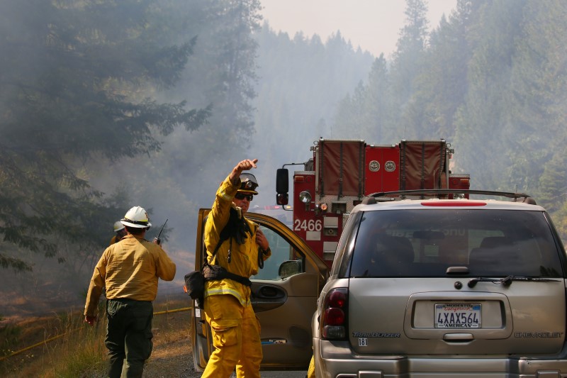
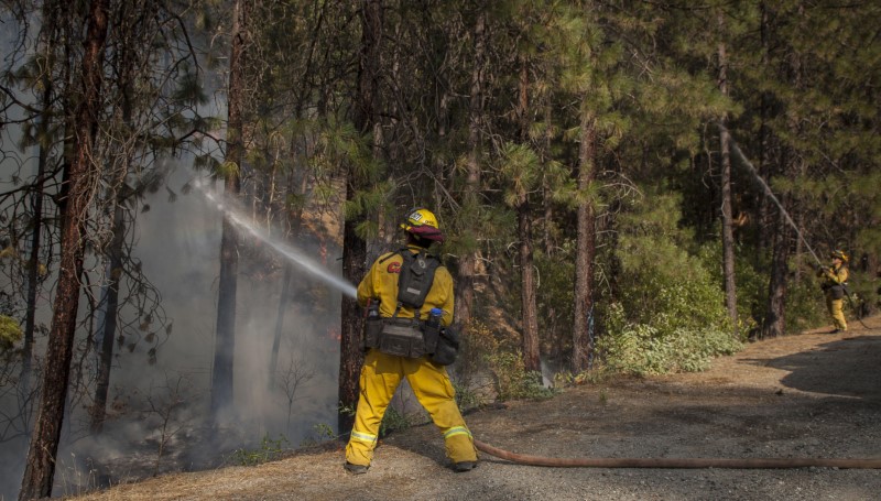
The so-called River Fire scorched 1,400 acres (566 hectares) in Placer and Nevada counties, with 1,000 acres burnt within the first two hours, the California Department of Forestry and Fire Protection (Cal Fire) said.

The River Fire was less than 100 miles (160 km) south of the enduring Dixie Fire, which according to Cal Fire has consumed 278,000 acres and was only 35% contained three weeks after it started.

Social media images showed the Dixie Fire on Wednesday had destroyed multiple structures in one section of Greenville, a town of about 800 people in Plumas County.

The River Fire was not at all contained, but officials said they expected cooler overnight weather and a reversal of the wind direction to help.

At least four homes were destroyed in Colfax, a Placer County town of 2,000 people about 50 miles (80 km) northeast of Sacramento, according to a Reuters witness. Officials said they would have an estimate of the property damage on Thursday.

At least 2,400 people had evacuated their homes in Placer County, and another 4,200 people were under evacuation orders in Nevada County, fire and law enforcement officials told a news conference.

Evacuation centers were established in both counties, and an animal shelter for pets was set up at a fairground.

“If you received an evacuation warning, please go. If you received an order, get out,” Placer County Sheriff Devon Bell told the news conference.

“Our hearts are with our communities, our friends, our neighbors who have been impacted by this incident,” Bell said.

Carrie Levine, a fire ecologist from nearby Grass Valley, said her family had evacuated even without an official warning because the fire was moving so fast.

“There’s a big column of smoke. It’s pretty dark, kind of like a purple, gray, eerie smoke. It’s in a pretty steep river canyon, and they really like to just blow up river canyons with the wind,” said Levine, who studies fire fuels and develops models for a private company.

Another expert urged people to evacuate because the area was particularly risky.

“In an analysis we did a couple years ago for an insurer, the Colfax/Auburn/Grass Valley area was one of the highest risk areas in the state for a catastrophic loss wildfire,” Crystal Kolden, a pyrogeographer at the University of California Merced, said on Twitter.

More than a dozen wildfires were burning around the state, which typically experiences peak fire season later in the year. California was on pace to suffer even more burnt acreage this year than last year, which was the worst fire season on record.

(Reporting by Fred Greaves in Colfax, California, and Daniel Trotta in Carlsbad, California)

Calmer winds bring hope in battle against deadly California blaze

Jul 30, 2018; Redding, CA, USA; Firefighters monitor fire movement as it crosses Highway 299 just west of Buckhorn Summit near the Trinity County line. Firefighters made progress on the fire which is now at 20 percent containment. Kelly Jordan via USA TODAY NETWORK

By Bob Strong

REDDING, Calif. (Reuters) – Some 3,600 firefighters struggling against one of the most destructive wildfires in California’s history hoped calmer winds on Tuesday would allow them to make more progress in carving out buffers to contain the blaze.

Six people have been confirmed killed and seven others have been missing since last Thursday. More than 800 homes and 300 other buildings have been reduced to ash and 37,000 people forced to evacuate as the Carr fire consumed 104,000 acres (42,000 hectares) in and around the town of Redding.

Jul 30, 2018; Redding, CA, USA; Todd Abercrombie, of Cal Fire watches the fire behavior as firefighters monitor fire movement as it crosses Highway 299 just west of Buckhorn Summit near the Trinity County line. Firefighters made progress on the fire which is now at 20 percent containment. Kelly Jordan via USA TODAY NETWORK

Jul 30, 2018; Redding, CA, USA; Todd Abercrombie, of Cal Fire watches the fire behavior as firefighters monitor fire movement as it crosses Highway 299 just west of Buckhorn Summit near the Trinity County line. Firefighters made progress on the fire which is now at 20 percent containment. Kelly Jordan via USA TODAY NETWORK

The firefighters reported some progress on Monday, having carved buffer lines around 23 percent of the fire’s perimeter, up from just 5 percent during much of the past week, thanks to calmer winds expected to remain in the area for two days.

The blaze, so far the seventh most destructive in Californian history, roared without warning into Redding and adjacent communities last week after being whipped by gale-force winds into a firestorm that jumped the Sacramento River.

It is the biggest of 17 wildfires now raging across the state, fueled by drought-parched vegetation, triple-digit temperatures, and unpredictable winds.

Two firefighters and at least four civilians were killed, including two young children and their great-grandmother who perished while huddled under a wet blanket.

Whole neighborhoods, including the town of Keswick on the outskirts of Redding, were laid to waste as residents fled for their lives in a chaotic evacuation. On Monday authorities began allowing some to return home, though an estimated 37,000 people still remained under mandatory evacuation orders.

Jul 30, 2018; Redding, CA, USA; Firefighters monitor fire movement as it crosses Highway 299 just west of Buckhorn Summit near the Trinity County line. Firefighters made progress on the fire which is now at 20 percent containment. Kelly Jordan via USA TODAY NETWORK

Jul 30, 2018; Redding, CA, USA; Firefighters monitor fire movement as it crosses Highway 299 just west of Buckhorn Summit near the Trinity County line. Firefighters made progress on the fire which is now at 20 percent containment. Kelly Jordan via USA TODAY NETWORK

To the southwest, the River and Ranch wildfires, known as the 23,000-acre Mendocino Complex, has forced thousands to evacuate as it has threatened 10,000 homes. About 2,000 firefighters are battling the blazes about 150 miles (240 km)north of San Francisco, where it has destroyed seven homes since it began on Friday, fire officials said.

Collectively, wildfires that have burned mostly in the U.S. West have scorched 4.6 million acres so far this year, 24 percent more than the average of burned landscape tallied for the same period over the past decade, according to federal data.

Authorities in California have reported levels of fire intensity and unpredictability they have seldom seen before. Statewide, wildfires have charred nearly 410,000 acres since January, the highest year-to-date total for the end of July in a decade, according to CalFire.


(Additional reporting by Brendan O’Brien; Editing by Richard Balmforth)