Flooding expected to worsen in Carolinas after Florence’s departure

Emergency personnel and local media drive through flooded streets to assess the damage caused by Hurricane Florence, in Spring Lake, North Carolina, September 17, 2018. Spc. Austin T. Boucher/U.S. Army/Handout via REUTERS

By Anna Mehler Paperny

KINSTON, N.C. (Reuters) – Flooding from rain-swollen rivers was expected to worsen across the Carolinas on Thursday and the next couple of days in the aftermath of Hurricane Florence, which killed 36 people in three states, forecasters said.

Twenty flood gauges showed some level of flooding in North Carolina, South Carolina and Virginia, where some major waterways, well above their flood stages, were expected to rise through the weekend before they crest, the National Weather Service said.

“People in flood prone areas or near waterways need to remain alert as rivers crest and stay above their banks in coming days,” North Carolina Governor Roy Cooper said in a written statement. “Stay alert and stay safe.”

Touring the area on Wednesday, U.S. President Donald Trump warned South Carolina that “water is coming your way.”

“Now it looks nice but it’s really the calm before the storm,” he said.

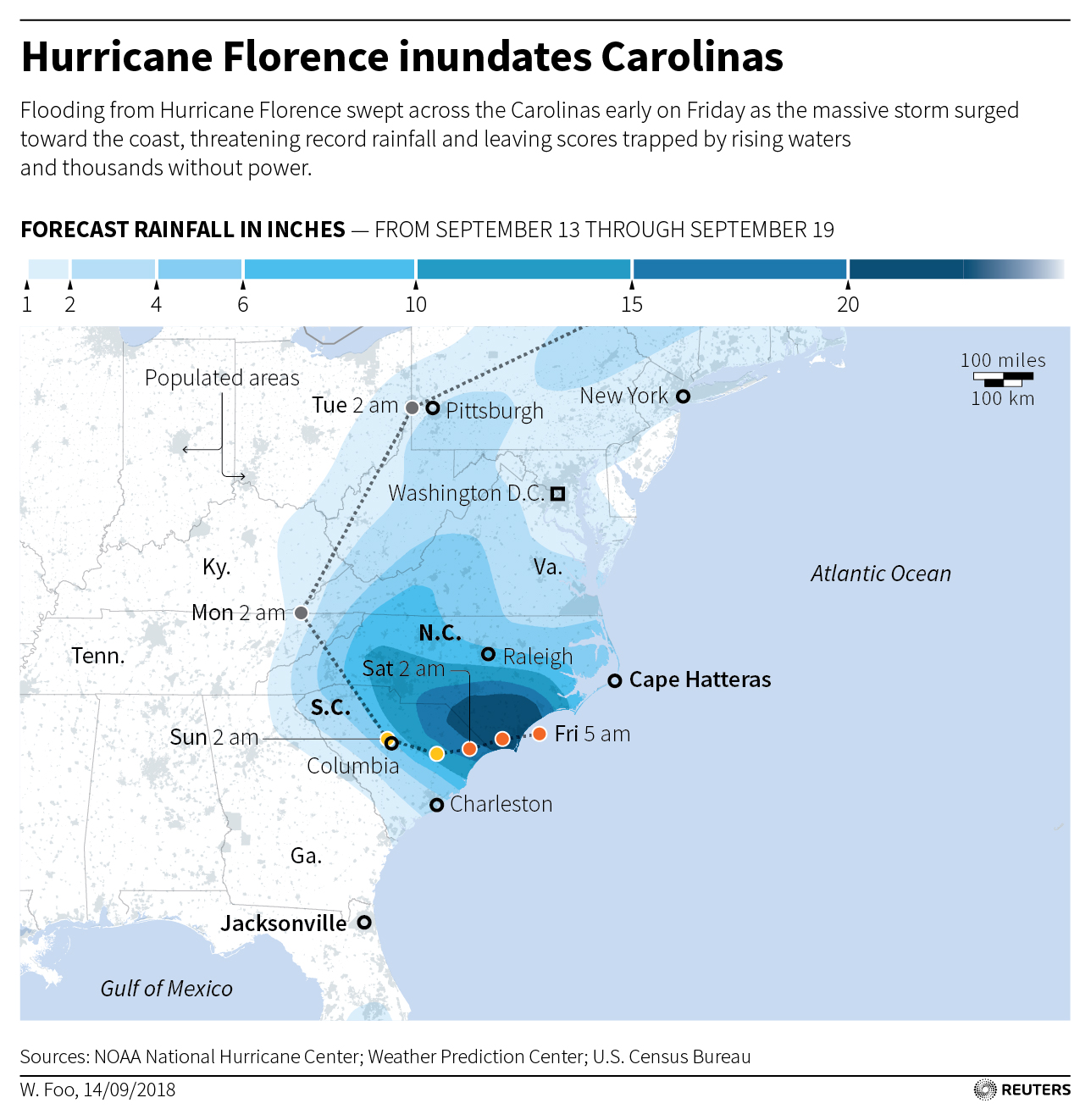
Florence dumped up to 36 inches (91 cm) of rain on parts of North Carolina and many areas remained cut off by floodwaters and inundated roads. The slow-moving storm made landfall on Friday as a Category 1 hurricane.

In Lenoir County, North Carolina, where the rising Neuse River has flooded some roads, emergency medical workers have been running a “mobile disaster hospital,” which provides urgent care to residents cut off from the nearest hospital.

Tripp Winslow, medical director of North Carolina Emergency Medical Services, helped set up the mobile emergency room during a downpour on Saturday night. They have received 20 to 30 patients a day so far, he said, but expect to be busier as the river crests.

“Once we get isolated we expect to see more,” he said. “No pun intended, it’s a fluid situation.”

Members of the National Guard work on a long sand bag flood barrier being built by the South Carolina Department of Transportation on U.S. 501 to lesson damage to roads anticipated from floods caused by Hurricane Florence, now downgraded to a tropical depression, in Conway, South Carolina, U.S. September 19, 2018. REUTERS/Randall Hill

Members of the National Guard work on a long sand bag flood barrier being built by the South Carolina Department of Transportation on U.S. 501 to lesson damage to roads anticipated from floods caused by Hurricane Florence, now downgraded to a tropical depression, in Conway, South Carolina, U.S. September 19, 2018. REUTERS/Randall Hill

MANY STILL WITHOUT POWER

At least 36 deaths have been attributed to the storm, including 27 in North Carolina, eight in South Carolina and one in Virginia.

Some 2,600 people had been rescued by boat or helicopter in North Carolina alone since the storm made landfall, and about 10,000 people remain in shelters, according to state officials.

More than 121,000 customers were without power across North Carolina, and more than 2.1 million customers across the southeast United States were affected by the storm, according to utilities.

Duke Energy Corp started to return its Brunswick nuclear power plant in North Carolina to service on Thursday. The company shut both reactors at the 1,870-megawatt facility before Florence hit the coast near the plant in Southport, about 30 miles (48 km) south of Wilmington.

One megawatt can power about 1,000 U.S. homes.

As floodwaters continue to rise, concerns are growing about the environmental and health dangers lurking in the water.

The flooding has caused 21 hog “lagoons,” which store manure from pig farms, to overflow, creating a risk that standing water will be contaminated, according to the state’s Department of Environmental Quality. North Carolina is one of the leading hog-producing states in the country.

Several sewer systems in the region also have released untreated or partly treated sewage and storm water into waterways over the last week, local media reported.

Experts have said that climate change has increased the likelihood of more massive, sluggish storms like Florence, capable of dropping record amounts of rain and touching off catastrophic flooding.

(Reporting by Anna Mehler Paperny in Kinston, North Carolina; Additional reporting by Jeff Mason in Conway, South Carolina, Brendan O’Brien in Milwaukee, and Scott DiSavino in New York; Writing by Joseph Ax; Editing by Larry King and Bill Trott)

North Carolina feels first bite of mammoth Hurricane Florence

A man walks his dogs before Hurricane Florence comes ashore on Carolina Beach, North Carolina, U.S., September 13, 2018. REUTERS/Carlo Allegri

By Ernest Scheyder

WILMINGTON, N.C. (Reuters) – Coastal North Carolina felt the first bite of Hurricane Florence on Thursday as winds began to rise, a prelude to the slow-moving tempest that forecasters warned would cause catastrophic flooding across a wide swath of the U.S. southeast.

The center of Florence, no longer classified as a major hurricane but still posing a grave threat to life and property, is expected to hit North Carolina’s southern coast Friday, then drift southwest before moving inland on Saturday, enough time to drop feet of rain, according to the National Hurricane Center.

Businesses and homes in the storm’s path were boarded up and thousands of people had moved to emergency shelters, officials said, urging anyone who remained near the coast to flee. Millions were expected to lose power, perhaps for weeks.

“There is still time to leave,” North Carolina Governor Roy Cooper told “CBS This Morning” on Thursday. “This is an extremely dangerous situation.”

Florence’s maximum sustained winds were clocked on Thursday at 110 miles per hour (175 kph) after it was downgraded to a Category 2 on the five-step Saffir-Simpson scale, according to the NHC. The storm was about 170 miles (275 km) east of Wilmington, North Carolina.

Tropical storm-force winds of at least 39 miles per hour (63 kph) extended outward up to 195 miles (315 km) from its center and were due to begin raking North Carolina’s Outer Banks barrier islands around 8 a.m. (1200 GMT) before stretching over low-lying areas reaching from Georgia north into Virginia.

The rain posed a greater danger, forecasters warned, with some spots getting as much as 40 inches (1 m) of precipitation, enough to cause devastating flash floods miles from the coast.

In all, an estimated 10 million people live in areas expected to be placed under a hurricane or storm advisory, according to the U.S. Weather Prediction Center. More than one million people had been ordered to evacuate the coastlines of the Carolinas and Virginia.

Besides inundating the coast with wind-driven storm surges of seawater as high as 13 feet (four meters) along the Carolina coast, Florence could dump 20 to 30 inches (51-76 cm) of rain over much of the region.

If it stalls over land, downpours and flooding would be especially severe. Heavy rains were forecast to extend into the Appalachians, affecting parts of Alabama, Tennessee, Kentucky and West Virginia.


TEST FOR TRUMP

The storm will be a test of President Donald Trump’s administration less than two months before elections that will determine control of Congress. After facing severe criticism for its handling of last year’s Hurricane Maria, which killed some 3,000 people in Puerto Rico, Trump has vowed a vigorous response.

“We are completely ready for hurricane Florence, as the storm gets even larger and more powerful. Be careful!” Trump said on Twitter.

The head of the Federal Emergency Management Agency, which is in charge of disaster response, has come under investigation over his use of government vehicles, Politico reported on Thursday.

Emergency declarations were in force in North and South Carolina, Virginia, Maryland and the District of Columbia.

Emergency preparations included activating more than 2,700 National Guard troops, stockpiling food, setting up shelters, switching traffic patterns so major roads led away from shore, and securing 16 nuclear power reactors in the Carolinas and Virginia.

Some in Wilmington could not resist getting one last look at their downtown before the storm hit.

“We just thought we’d go out while we still can,” said Amy Baxter, on a walk near the city’s waterfront with her husband, two sons, and dog.

Baxter, a 46-year-old homemaker, and her family plan to ride out Florence at home with board games and playing cards.

“We live in a house that’s more than 100 years old,” Baxter said. “We feel pretty safe.”

(For graphic on forecast rainfall in inches from Hurricane Florence, click https://tmsnrt.rs/2oZFKSb)

(Additional reporting by Bernie Woodall in Fort Lauderdale, Florida, Brendan O’Brien in Milwaukee and Stephanie Nebehay in Geneva; Editing by Scott Malone)

Storm Julia dumping heavy rains on Georgia and South Carolina coasts

Tropical Storm Julia and other storms lined up in the Atlantic

(Reuters) – Tropical Storm Julia dumped heavy rains along coastal Georgia and South Carolina on Wednesday, weakening as it drifted north along the U.S. Southeast coast, the National Hurricane Center said.

The storm, centered around southeastern Georgia, had gusting winds as strong as 40 mph (65 kph). Heavy rain and high tides threatened low-lying coastal areas prone to flooding, such as parts of Charleston, South Carolina, forecasters said.

“It’s weakening, but it will still continue to produce heavy rain and that is the main hazard that we are concerned with,” said Bob Bright, a meteorologist with the National Weather Service in Charleston.

Julia, the 10th named storm of the 2016 Atlantic hurricane season, is expected to weaken to a tropical depression on Wednesday as it moved north at 7 mph, the Miami-based hurricane center said.

At 8 a.m. (1200 GMT), Julia was about 10 miles (16 km) west of Brunswick, Georgia, the hurricane center said.

Northeast Florida felt the storm’s strong blasts and bands of rain after it came ashore late on Tuesday around Cape Canaveral, forecasters said.

The National Weather Service in Jacksonville, Florida, whose coverage area includes southeastern Georgia, had received reports of toppled trees, but not significant structural damage on Wednesday morning, meteorologist Scott Cordero said.

“We had some pretty good winds associated with it,” he said. “She is starting to lose her tropical characteristics, as she is remaining mainly landlocked.”

(Reporting by Letitia Stein in Tampa, Fla., Brendan O’Brien in Milwaukee, and Swati Verma in Bengaluru; Editing by Andrew Heavens and James Dalgleish)

Hermine lingers off U.S. East Coast

A woman walks her dog at Rockaway Beach in Queens, New York on Labor Day while high waves reached the shore due to post-tropical cyclone Hermine which tracked off the east coast of the U.S.

Reuters) – Hermine, a storm that raked Florida with hurricane-force winds last week, lingered on Tuesday off the U.S. East Coast where it was expected to produce heavy gusts and rain over the next two days.

Forecasters warned swimmers and boaters to stay out of treacherous waters and rough surf. New York City said all public beaches would be closed through Tuesday because of “life-threatening” rip currents.

At 2 a.m. EDT on Tuesday, Hermine’s center was about 110 miles (175 km) southeast of the eastern tip of Long Island and expected to move northwest at about 9 mph (15 kph).

Hermine was forecast to bring up to 2 inches (5 cm) of rain to Rhode Island and southern Massachusetts through Wednesday, the National Weather Service said.

A tropical storm warning remained in effect from the eastern end of New York’s Long Island and to Martha’s Vineyard and Nantucket Island off Massachusetts.

On Cape Cod and its islands, high surf and wind put a crimp in the Labor Day plans of many people looking to celebrate summer’s end, but some beaches farther south reopened.

Hermine was classified as a Category 1 hurricane when it slammed into Florida’s Gulf Coast on Friday. It became a post-tropical storm by week’s end after its winds dropped below 74 miles per hour (119 kph) and it lost its tropical characteristics.

The storm, which crossed northern Florida and then moved up the Georgia and the Carolina coasts, was packing sustained surface winds of up to 65 mph (100 kph) with higher gusts, the National Weather Service said.

“Just because it’s a post-tropical cyclone doesn’t mean the impact of tropical force winds, winds in general and storm surge go away,” said National Hurricane Center spokesman Dennis Feltgen.

The storm has claimed at least three lives, in Florida and in North and South Carolina. The third reported death was that of a man struck by a car on a South Carolina highway on Friday as he tried to move a fallen tree, a Colleton County fire department spokesman said.

Hermine became the first hurricane to make landfall in Florida in 11 years, packing winds of 80 mph (130 kph), and knocking out power to 300,000 homes and businesses.

(Reporting by Brendan O’Brien in Milwaukee)