Blizzard moves towards Plains and Midwest after waning in the U.S. Rockies

A general view of the blizzard in Greeley, Colorado, U.S. March 13, 2019 in this picture obtained from social media. Mandatory credit TWITTER @PHOTOWILLG/via REUTERS

By Keith Coffman

DENVER (Reuters) – A powerful storm bringing heavy snowfall and strong winds was churning across the U.S. Plains and Midwest on Thursday, a day after a blizzard in the Rocky Mountains grounded flights, caused power outages and raised fears of further Midwest flooding after a deluge last month.

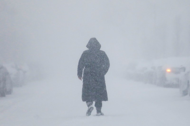
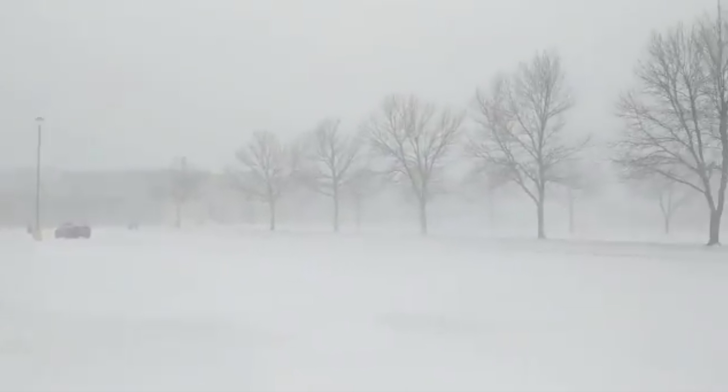
Warm spring temperatures on Tuesday, upwards of 80 degrees Fahrenheit in Denver, gave way to frigid 20s, heavy snow, gale-force winds and life-threatening conditions through Thursday, the National Weather Service said.

David Roth, a meteorologist with the weather service’s Weather Prediction Center, said that while the Rockies were expected to receive constant precipitation until Saturday, the center of low pressure of the blizzard was spinning into the U.S. Plains and Midwest.

Roth said the storm system will turn northeast into Minnesota late on Thursday and then slowly move into Lake Superior by Friday night.

Heavy snow with blizzard conditions was expected through Thursday night in southeastern South Dakota and southwestern Minnesota, the weather service said.

Despite the severe weather, crew members at Denver International Airport worked through the night to remove snow from runways, and only about 180 flights were canceled on Thursday morning, down from more than 700 a day earlier, according to FlightAware.come, a flight tracking service, and airport officials.

“Some cancellations and delays are expected today, so be sure to check your flight status with your airline!” airport officials wrote on Twitter on Thursday.

Residents throughout the north-central United States could expect downed trees, widespread power outages, road closures and treacherous driving through Friday, the NWS said.

More than 10,000 homes and businesses were without power in South Dakota and about another 10,000 in Minnesota early Thursday.

Officials in Colorado ordered state government offices in 54 counties to be closed on Thursday, according to a statement posted on Facebook. Government offices in Denver were closed on Wednesday afternoon due to weather conditions, according to a statement on the state’s website.

Brian Hurley, another meteorologist with the weather service, had previously described the powerful blizzard as a “bomb cyclone,” the second one to hit the area in two months.

“This is like a slow-moving snowstorm inside a hurricane,” Hurley said, adding that wind gusts were upwards of 100 mph on Wednesday in eastern Colorado.

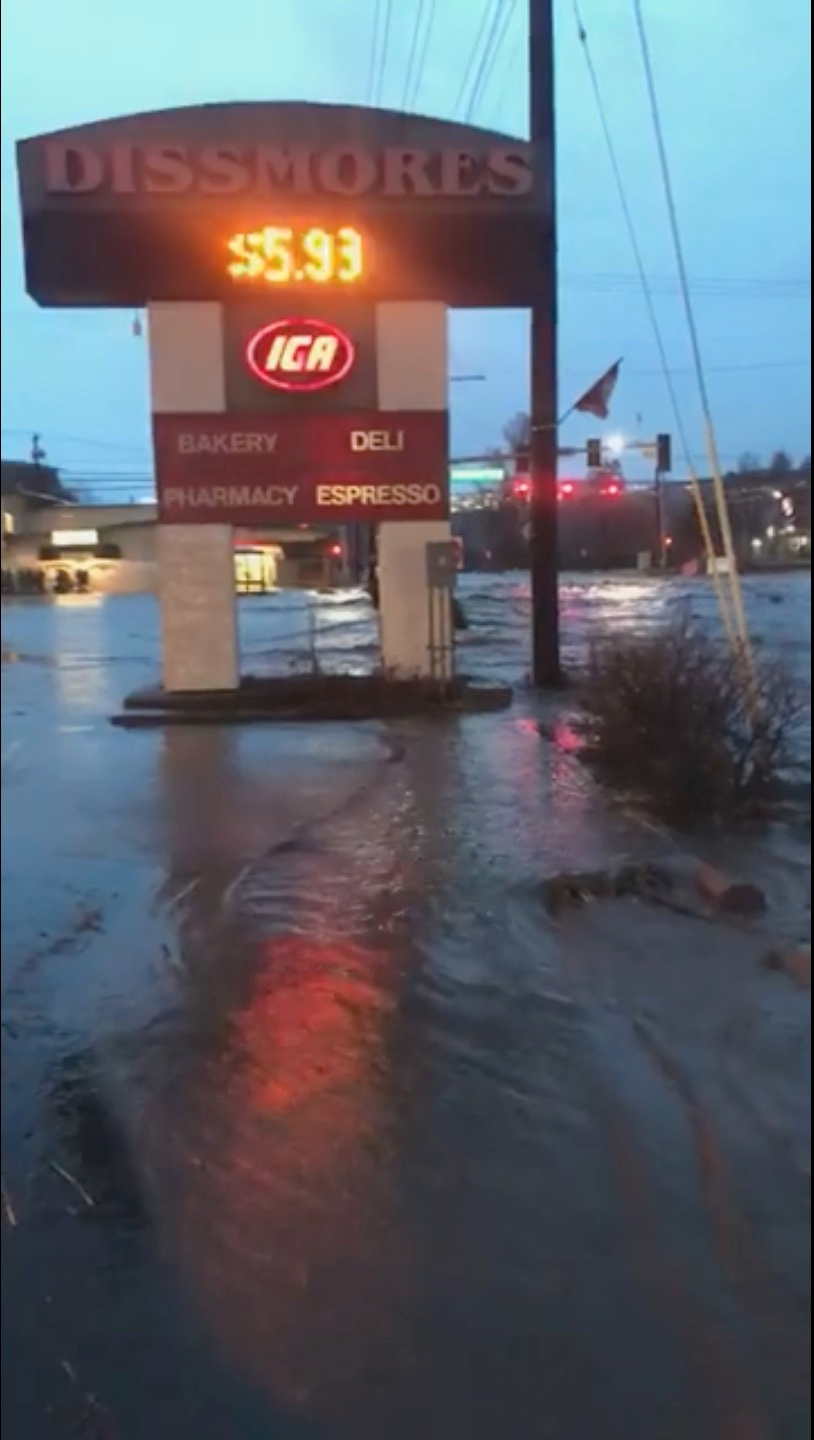
In March, another “bomb cyclone,” which involves a rapidly intensifying cyclone, triggered heavy rain over the region and combined with melting snow to cause flooding along the Missouri River and its tributaries. Damages and losses to property, cattle and crops in Nebraska and Iowa alone were estimated at more than $3 billion .

This week’s weather system is expected to weaken and move to the Great Lakes area on Friday, bringing rain and snow to that region, the Weather Service said.

“All that snow is going to melt sooner rather than later, and it’ll all flow into the Missouri River basin,” Hurley said.

(Additional writing and reporting by Rich McKay in Atlanta; additional reporting by Andrew Hay in Taos, New Mexico; Gina Cherelus in New York and Alex Dobuzinskis in Los Angeles; editing by Larry King and Bernadette Baum)

Millions in central U.S. brace for ‘life-threatening’ blizzards, potential floods

Floodwaters flow along a street in Pullman, Washington, U.S. in this still image taken from April 9, 2019 social media video. ELLIE STENBERG/via REUTERS

(Reuters) – A blizzard hitting the U.S. Rockies on Wednesday was forecast to move eastward over the next day, threatening to bring new flooding to the Plains states including parts of South Dakota and Missouri that are still recovering from last month’s inundation.

High spring temperatures will give way to heavy snow, gale-force winds and life-threatening conditions across a swathe of the central United States running from the Rockies to the Great Lakes, according to the National Weather Service.

“This is potentially a life-threatening storm,” Patrick Burke, a meteorologist with the NWS’s Weather Prediction Center in Maryland, said Wednesday.

A sign for shops is seen as floodwaters flow along a street in Pullman, Washington, U.S. in this still image taken from April 9, 2019 social media video. ELLIE STENBERG/via REUTERS

A sign for shops is seen as floodwaters flow along a street in Pullman, Washington, U.S. in this still image taken from April 9, 2019 social media video. ELLIE STENBERG/via REUTERS

A cyclone last month dropped heavy rains over that region, causing extensive flooding along the Missouri River and more than $3 billion in damage to property and crops in Nebraska and Iowa.

Pueblo, Colorado, hit 85 degrees Fahrenheit (30 Celsius) on Tuesday, but will drop down to 25F (minus 4C) by early Thursday. Similar temperatures are forecast in Denver.

The storm is expected to bring blinding, heavy wet snow across the region, likely downing trees and causing widespread power outages, widespread road closures and making driving treacherous, Burke said.

“It’s slow moving. It won’t push farther east until Friday,” he said.

Some areas of western Minnesota and southeast South Dakota were expected to get up to 30 inches of wet, heavy snow, the NWS said.

Two factors may limit the flooding effect, forecasters said. Thawed ground will be able to absorb more precipitation than last month’s frozen ground and a fall of heavy snow rather than rain will slow the runoff process.

Nearly 500 flights were canceled at Denver International Airport on Wednesday, about a quarter of its total schedule, according to FlightAware.com, an airline tracking website.

Airport officials said they had snow-removal crews in place.

The coming storm was expected to exacerbate flooding along the Missouri River in areas where dozens of levees were breached in March, exposing communities to future surges. The river was not expected to crest in areas of Nebraska, Iowa and Missouri until between three to five days after the storm.

The storm is expected to weaken and push off into the Great Lakes area and northern Michigan on Friday, bringing more rain and snow, the weather service said.

(Reporting by Andrew Hay in Taos, New Mexico, Rich McKay in Atlanta and Gina Cherelus in New York; Editing by Alison Williams and Susan Thomas)

More floods loom as high river waters recede in Midwest

FILE PHOTO - The Kansas side of the Missouri River is seen in Atchison, Kansas, U.S., March 22, 2019 in this picture obtained from social media. SHAWN RIZZA/via REUTERS

By Karen Dillon

KANSAS CITY, Mo. (Reuters) – Record floods that submerged parts of three Midwestern states bringing death and destruction were retreating in Kansas City on Monday but icy tributaries in Montana and the Dakotas threatened more floods for weeks to come, the National Weather Service said.

High flood waters have already returned in the western Dakotas, northwest Nebraska and central and eastern Montana, along smaller rivers that feed into the Missouri, David Roth, a meteorologist with the NWS’s Weather Prediction Center in College Park, Maryland, said on Monday.

Warmer weather makes the once solid river ice break-up into giant chunks, like mini-icebergs, Roth said.

“The ice floats down river until it bunches up in what we call an ice-jam, like a dam, causing flooding,” he said.

“All that backed-up water is eventually going downstream,” Roth said. “It’ll come down the Missouri in a couple of weeks, and maybe hit Kansas City in mid-April.”

Midwest floods were unleashed last week after a “bomb cyclone” storm dumped torrential rains on hundreds of square miles (km) of the snow-covered Plains.

The record flows cascaded down the Missouri, the country’s longest river, killing at least four people, drowning livestock and closing dozens of roads in Nebraska and Iowa. Property losses were estimated at more than $3 billion in those two states.

Those flood waters crested near Kansas City on Sunday, the weather service said.

No further precipitation is forecast for the Midwest until midweek, when moderate rainfall is expected, NWS’s Andrew Orrison said Sunday.

“I think at the worst what it will do is just prolong the gradual receding of the water levels across the various river basins throughout the Midwest.”

The current flooding threatens Kansas City’s drinking water. More than 600,000 customers in the Kansas City metropolitan area were asked to conserve water as flood-levels in the Missouri River created “treatment challenges,” the city’s water utility said on Sunday.

But far up the nation’s longest river, floods loom again.

The Billings Gazette reported late Sunday that rapid snow melt drove ice jams on the Little Bighorn River, forced the shutdown of a stretches of major highways in eastern Montanta all the way to the Wyoming border.

But the bigger threat is warmer temperatures that will hit the upper 60s in Billings by Tuesday and into midweek, driving more snowmelt that will eventually flow south, said meteorologist Roth.

“All that water is still headed downstream,” he said.

(Reporting by Karen Dillon; Additional reporting and writing by Rich McKay in Atlanta; additional reporting by Peter Szekely and Andrew Hay, Editing by William Maclean)

Flooding will go on in storm-ravaged U.S. Midwest; $1 billion in damage, 4 dead

FILE PHOTO: A flooded parcel of land along the Platte River is pictured in this aerial photograph at La Platte, south of Omaha, Nebraska, U.S. March 19, 2019. REUTERS/Drone Base

(Reuters) – The flooding that devastated the U.S. Midwest is likely to last into next week, as rain and melted snow flow into Kansas, Missouri and Mississippi, the National Weather Service said.

Floods driven by melting snow in the Dakotas will persist even as Nebraska and Iowa dig out from storms that have killed four people, left one missing and caused more than a billion dollars in damage to crops, livestock and roads.

“It’s already not looking good downstream for the middle and lower Mississippi and Missouri (rivers) into Kansas, Mississippi and Missouri,” Bob Oravec, a meteorologist with the NWS’s Weather Prediction Center, said early Wednesday.

The floodwaters have inundated a swath of Iowa and Nebraska along the Missouri River, North America’s longest river. Half of Iowa’s 99 counties have declared states of emergency.

“That snowpack is still there and it’s going to keep melting, and that’s bad news,” Oravec said.

About an inch of rain is predicted for Saturday in the region, Oravec said. “It’s not a lot, but any precipitation is bad right now.”

Vice President Mike Pence toured some of Nebraska Tuesday and promised to help expedite federal help to the region.

FILE PHOTO: Homes sit in flood waters after leaving casualities and causing hundreds of millions of dollars in damages, with waters yet to crest in parts of the U.S. midwest, in Peru, Nebraska, U.S., March 19, 2019. REUTERS/Karen Dillon

FILE PHOTO: Homes sit in flood waters after leaving casualities and causing hundreds of millions of dollars in damages, with waters yet to crest in parts of the U.S. midwest, in Peru, Nebraska, U.S., March 19, 2019. REUTERS/Karen Dillon

Nebraska, Iowa and Wisconsin and Mississippi all declared states of emergency after the floods, which stemmed from a powerful winter hurricane last week. The flooding killed livestock, destroyed grains and soybeans in storage and cut off access to farms because of road and rail damage.

Authorities said they had rescued nearly 300 people in Nebraska alone, with some rivers continuing to rise. Rescuers could be seen in boats pulling pets from flooded homes. Some roadways crumbled to rubble and sections of others were submerged. In Hamburg, Iowa, floodwaters covered buildings.

$1 BILLION IN DAMAGE

Nebraska officials estimated flood damage for the state’s agriculture at more than $1 billion so far, according to Craig Head, vice president of issue management at the Nebraska Farm Bureau. Head said that was likely to grow as floodwaters recede.

“It’s really too early to know for sure how bad this is going to get. But one thing we do know: It’s catastrophic for farmers,” said Matt Perdue, government relations director for the National Farmers Union. “We’re hoping it’s only $1 billion, but that’s only a hope.”

Nebraska officials estimate the floods have also caused $553 million in damage to public infrastructure and other assets, and $89 million to privately owned assets, according to the state’s Emergency Management Agency on Tuesday.

The water covered about a third of Offutt Air Force Base near Omaha, Nebraska, home to the U.S. Strategic Command, whose responsibilities include defending against and responding to nuclear attacks.

The Army Corps of Engineers is distributing 400,000 sandbags to operators of 12 levees along the Missouri River in Missouri and Kansas that are threatened by flooding, the Army Corps said in a news release on Tuesday.

Roads leading to the Nebraska Public Power District’s Cooper nuclear plant near Brownville were engulfed by floodwaters from the Missouri, but the facility was still operating safely at full power on Tuesday.

The plant operator was flying staff members and supplies to the plant by helicopter, power district spokesman Mark Becker said.

(Reporting by Rich McKay in Atlanta; additional reporting by Karen Dillon in Brownville, Neb., Gina Cherelus in New York, Jarrett Renshaw in Philadelphia, P.J. Huffstutter and Mark Weinraub in Chicago and Dan Whitcomb in Los Angeles; editing by Larry King)

Isolation, evacuations in U.S. central Plains as floods kill three

Flooded Camp Ashland, Army National Guard facility, is seen in this aerial photo taken in Ashland, Nebraska, U.S., March 17, 2019. Picture taken March 17, 2019. Courtesy Herschel Talley/Nebraska National Guard/Handout via REUTERS

(Reuters) – Flooding that killed three people in the central plains of Nebraska and Iowa has cut roads to a nuclear power plant and inundated a large portion of a U.S. Air Force base, forcing it to work with a skeleton staff on Monday, while more of region’s residents possibly faced evacuation.

The floods, which have prompted each state’s governor to declare a state of emergency, are the result of last week’s “bomb cyclone” winter storm, a winter hurricane that blew in from the western Rocky Mountains. Three people died in the flooding and at least one person was missing after hundreds of weekend rescues.

Flooded Camp Ashland, Army National Guard facility, is seen in this aerial photo taken in Ashland, Nebraska, U.S., March 17, 2019. Picture taken March 17, 2019. Courtesy Herschel Talley/Nebraska National Guard/Handout via REUTERS

Flooded Camp Ashland, Army National Guard facility, is seen in this aerial photo taken in Ashland, Nebraska, U.S., March 17, 2019. Picture taken March 17, 2019. Courtesy Herschel Talley/Nebraska National Guard/Handout via REUTERS

The floodwaters forced the operators of the Cooper nuclear plant, near Brownville, Nebraska, to fly in staff and supplies by helicopter, and covered one-third of that state’s Offutt Air Force Base, near Bellevue, home to the U.S. Strategic Command. The nuclear plant continued to operate safely and was at full power, its operator said.

The National Weather Service reported that some of the region’s larger rivers were running at record highs above flood level, causing levy breaks. Some small towns and communities have been cut off by floods while others have seen fresh drinking water become scarce. Floodwaters destroyed many homes and businesses over the weekend.

The NWS reported that temperatures across the hardest-hit areas will reach above 50 degrees Fahrenheit (10 C) through midweek and exceed 60 Fahrenheit by Friday. That would speed the pace of snow melt across the region and contribute water to already swollen rivers, the NWS said, possibly forcing evacuations in communities along the Missouri River on the Nebraska and Iowa border, as well as along the Elkhorn and Platte rivers in Nebraska.

“There could be issues across portions of Nebraska and Kansas for the next seven days,” NWS meteorologist Jim Hayes said.

Nebraska Governor Pete Ricketts, who declared a statewide emergency last week, said on Monday that emergency officials have rescued about 300 people but that at least one person was missing.

At Offutt Air Force Base, 30 buildings had been flooded by up to 8 feet (2.4 m) of water and 30 more structures had been damaged, according to reports by the Omaha World-Herald, citing a base spokeswoman. Base officials did not immediately respond to a request for comment.

The flooding covered 3,000 feet of the base’s 11,700-foot runway, the World-Herald reported.

The weather was blamed for three deaths, including one person who died at home after failing to evacuate, and a man swept away while trying to tow a trapped car with his tractor.

In Iowa, one man died after he was submerged in floodwaters on Friday in Riverton, according to the Fremont County Sheriff’s Office.

Iowa Governor Kim Reynolds also issued an emergency proclamation at the outset of the flooding.

(Reporting by Gina Cherelus in New York and Rich McKay in Atlanta; Editing by Scott Malone)

‘Bomb cyclone’ pushes east across U.S. after winter siege of Midwest, Rockies

A general view of the blizzard in Greeley, Colorado, U.S. March 13, 2019 in this picture obtained from social media. Mandatory credit TWITTER @PHOTOWILLG/via REUTERS

(Reuters) – A powerful, late-winter “bomb cyclone” storm pushed east into the U.S. Midwest and the Great Lakes region on Friday after bombarding the Rocky Mountain and Plains states with blizzards, floods and tornados, prompting precautions at a Nebraska nuclear power plant.

In Iowa, a disaster proclamation by Governor Kim Reynolds, issued after reports of flooding, remained in effect overnight.

Nebraska Governor Pete Ricketts also issued an emergency declaration after rain-swollen rivers and dam breaches left many bridges and roads impassable and prompted thousands of residents of the farm state to evacuate.

“Widespread and extremely dangerous flooding will continue today and tonight,” the National Weather Service office in Omaha, Nebraska, said on Friday in a statement.

Many streams will see moderate to major flooding through the weekend, the service added, and flooding along the Missouri River will continue into next week.

The Nebraska Public Power District declared an “unusual event” at its Cooper Nuclear Station power plant on Friday due to the possibility of flooding along the Missouri.

Workers filled sandbags along the river levee and procured other materials for flood protection, the power agency said. It said the plant continued to operate safely and there was no threat to plant employees or to the public.

Thirteen tornados were reported on Thursday in Kentucky, Indiana and Michigan, said Bob Oravec, a meteorologist with the National Weather Service’s Weather Prediction Center in College Park, Maryland, but there were no immediate reports of serious damage.

Meteorologists referred to the storm as a “bomb cyclone,” a winter hurricane that forms when the barometric pressure drops 24 millibars in 24 hours.

At the storm’s peak, 2 feet of snow was dumped on Colorado’s mountain regions, forcing the cancellation of more than 1,300 flights in Denver and trapping more than 1,000 motorists on roadsides. Many had to be rescued by police, who used school buses to ferry them to safety.

There were no remaining blizzard warnings Friday, Oravec said.

“There’s still a good threat of thunderstorms in Louisiana, Mississippi and up into the Great Lakes region as the system pushes into Canada, but it’s not like it was,” he said.

Most power outages were cleared by early Friday, according to the tracking site PowerOutage.US, and air traffic returned to normal at Denver International Airport, a regional hub that was hardest hit by the storm.

(Reporting by Rich McKay; Additional reporting by Keith Coffman, Dan Whitcomb and Scott DiSavino; Editing by Mark Potter and Jonathan Oatis)

Historic blizzard wanes as it barrels east after pounding parts of U.S.

A general view of the blizzard in Greeley, Colorado, U.S. March 13, 2019 in this picture obtained from social media. Mandatory credit TWITTER @PHOTOWILLG/via REUTERS

By Keith Coffman

DENVER (Reuters) – A blizzard of “historic proportions” that hit the U.S. Rocky Mountain and Plains states this week was moving eastward on Thursday as it weakened, hurling hurricane-force winds and heavy rain on its way, weather officials said.

“While the storm has reached its lowest pressure and will gradually weaken over the next few days, strong winds will continue on the west side of the storm across portions of the Central and Northern Plains,” Bob Oravec, a meteorologist with the National Weather Service (NWS), said on Thursday in a weather advisory.

A day earlier, the NWS had described the cyclone as being of ‘historic proportions’ in a post on Twitter. Hurricane-force winds involve frequent gusts or sustained winds of more than 74 miles per hour.

The blizzard, bringing severe snowfall, poor visibility and powerful winds, caused hundreds of flight cancellations and thousands of power outages in Colorado and Texas. It was expected to unleash similar conditions over areas in Colorado, Wyoming, Nebraska, South Dakota and North Dakota before moving into northwest Minnesota, Oravec said.

While some flights resumed at Denver International Airport, the airport was not expected to be fully operational until midday on Thursday, as airlines were still dispatching more planes to Denver to replace those diverted or canceled earlier, airport spokeswoman Emily Williams told Reuters.

Flight cancellations were down to more than 600 on Thursday morning, from more than 1,300 in the region a day earlier, according to FlightAware.com.

Power outages in Colorado affected about 80,000 homes and businesses, down by 8,000. About 60,000 in Texas also experienced outages on Thursday, dropping by 17,000.

Stranded motorists across the region had been reached and given assistance before midnight, a spokesman for the Colorado State Patrol spokesman said early Thursday. Around 1,100 motorists were reported as stranded on Interstate 25 near Colorado Springs a day earlier.

A state of emergency was still in effect in Colorado as cities and towns dug out from the storm, during which strong, 70-mile-per-hour wind gusts pushed tractor trailers sidewise and left up to two feet of snow in some areas.

The storm was blamed for the death of a Colorado state trooper, who was hit by a car that slid on ice on the highway as he was attending to a car wreck.

Schools and government offices remained closed Thursday across the region.

The blizzard, previously dubbed a “bomb cyclone” by U.S. meteorologists for its quick, late-season punch, was still expected to prompt warnings of blizzards and snow before noon in north-central Kansas and Nebraska, Brian Hurley, a meteorologist with the National Weather Service, said early on Thursday.

Remnants of the snowfall and rain would clear from Denver and the mountain and plains areas by midday, he said.

(Reporting by Keith Coffman in Denver; writing and additional reporting by Rich McKay in Atlanta and Gina Cherelus in New York; Editing by Bernadette Baum)

Colorado trooper killed as ‘Bomb Cyclone’ unleashes snow, high winds

A policeman talks to a driver as snow clogs the roads in Lone Tree, Colorado, U.S. in this March 13, 2019 handout photo. City of Lone Tree, Colo./Handout via REUTERS

By Keith Coffman

DENVER (Reuters) – A late-winter blizzard slammed U.S. Rocky Mountain and Plains states on Wednesday, unleashing a “bomb cyclone” of high winds and drifting snow that stranded motorists, canceled more than 1,300 airline flights and was blamed for the death of a Colorado state trooper.

Colorado Governor Jared Polis declared a state of emergency due to the storm and said he had activated the state National Guard to assist in search and rescue operations.

Corporal Daniel Groves, 52, of the Colorado State Patrol is pictured in this undated handout photo obtained by Reuters March 13, 2019. Colorado State Police/Handout via REUTERS

Corporal Daniel Groves, 52, of the Colorado State Patrol is pictured in this undated handout photo obtained by Reuters March 13, 2019. Colorado State Police/Handout via REUTERS

The National Weather Service issued blizzard warnings for parts of Colorado, Wyoming, Nebraska and the Dakotas as schools and businesses were closed and local authorities urged residents to hunker down.

Meteorologists referred to the storm as a “bomb cyclone,” a winter hurricane that forms when the barometric pressure drops 24 millibars in 24 hours.

“So far, we have received 110 traffic crash reports and #Denver remains on #AccidentAlert,” the Denver Police Department said on Twitter.

“If you absolutely have to head out, please be cautious- it’s still #snowgoing out there. Turn your lights on, set the wipers on high; don’t forget the extra stopping distance. #BombCyclone”

The Colorado State Patrol said one of its troopers, Corporal Daniel Groves, was struck by a car that veered out of control on Interstate 76 and he died of his injuries a short time later at Platte Valley Medical Center in Brighton.

At the time, Groves, 52, was on the scene of another accident in which a vehicle had slid off the roadway, the state patrol said. It added that “high speed in poor driving conditions” was being investigated in connection with the crash that caused his death.

A general view of the blizzard in Greeley, Colorado, U.S. March 13, 2019 in this picture obtained from social media. Mandatory credit TWITTER @PHOTOWILLG/via REUTERS

A general view of the blizzard in Greeley, Colorado, U.S. March 13, 2019 in this picture obtained from social media. Mandatory credit TWITTER @PHOTOWILLG/via REUTERS

FLIGHTS DELAYED, CANCELED

All six runways at Denver International Airport were shuttered, along with the main road into the airport due to drifting, blowing snow. An airport spokesman said 1,339 flights had been canceled as of mid-afternoon. Colorado Springs Municipal Airport canceled all incoming flights.

All school districts in the seven-county Denver metropolitan were closed, along with most city and state government offices and many businesses.

Officials in El Paso County, Colorado, said some 1,100 motorists were stranded on Interstate 25 near Colorado Springs.

Utility company Xcel Energy said about 130,000 commercial and residential customers in Colorado were without power due to high winds and wet heavy snow.

“Limited visibility has affected our ability to respond,” Xcel Energy spokesman Mark Stutz said, adding it was unclear when power would be restored.

The police department in Northglenn, Colorado, tweeted a picture of a large tree that fell on a home, breaking through the roof. It was not immediately clear if anyone was hurt.

Interstate 70 was closed east of Denver to the Kansas state line and sections of Interstate 25 were also shut down, according to Colorado Department of Transportation.

“They typically do get strong systems this time of the year in that part of the country, but this one is maybe a notch stronger than what you typically see,” said meteorologist Marc Chenard of the weather service’s Weather Prediction Center in College Park, Maryland.

Forecasters said they expect winds of up to 70 miles per hour (110 kph) to sweep across a wide area of states to the south, including New Mexico and parts of Texas, Oklahoma and Kansas.

“Pretty much through much of the Plains there’s going to be a threat for potential power outage issues,” Chenard said.

More than 100,000 electric power customers in the Dallas-Fort Worth area were left in the dark early on Wednesday after a line of rain squalls associated with the system moved through the area.

The storm was also expected to bring heavy rain to areas of eastern Nebraska, Iowa, Wisconsin and Minnesota that already have a good deal of snow on the ground, raising the threat of river flooding, the weather service said.

The storm system is expected to weaken by Thursday as it moves over the Tennessee River Valley, bringing mostly rain from Michigan southward to the Gulf Coast and some remaining snow only in the far northern parts of the country, the weather service said.

(This story corrects name of Colorado governor in second paragraph)

(Reporting by Keith Coffman in Denver; additional reporting Peter Szekely in New York, Brendan O’Brien in Milwaukee and Dan Whitcomb in Los Angeles; Writing by Dan Whitcomb in Los Angeles; Editing by Bill Tarrant and Sandra Maler)

Blizzard threatens U.S. central plains with two feet of snow

A woman walks down the street during a blizzard in Long Beach, New York, U.S. January 4, 2018.

By Peter Szekely

(Reuters) – A late-winter storm this week could dump up to two feet (60 cm) of snow in the U.S. central Plains states, potentially snarling travel and bringing flooding to the Upper Midwest, U.S. forecasters said on Tuesday.

The storm, now brewing as low-pressure center in the southwest, will quickly move into the Rocky Mountains and deliver one to two feet of snow with blizzard conditions in much of Colorado and parts of Wyoming, Nebraska and South Dakota, the National Weather Service predicted.

The biggest air travel hub likely to be affected by the snow is Denver International Airport, but cross-continental air travel lanes could be disrupted as well as the system brings a line of rain squalls eastward, forecasters said.

“The snow will really start picking up by later tonight into the day on Wednesday,” meteorologist Mark Chenard said in a Tuesday phone interview from the NWS Weather Prediction Center in College Park, Maryland.

The storm will also bring heavy rain to areas of eastern Nebraska, Iowa, Wisconsin and Minnesota that already have a good deal of snow on the ground, the NWS said.

“We could have the potential for major river flooding, given the rain and the snow melt,” Chenard said.

An earlier round of heavy, wet snow caused several roofs to collapse in the Upper Midwest last weekend, including those of a church and a hotel.

By Thursday, the storm system will weaken as it moves over the Tennessee River Valley, bringing mostly rain from Michigan southward to the Gulf Coast and some remaining snow only in the far northern parts of the country, he added.


(Reporting by Peter Szekely in New York; Editing by Scott Malone and Steve Orlofsky)

Commuter jet slides off Maine runway as East Coast digs out from snow

A woman makes her way through the snow on cross country skis during a winter storm in Pallisades, New York March 4, 2019. REUTERS/Mike Segar

By Barbara Goldberg and Dan Whitcomb

(Reuters) – New England dug out from more than a foot of snow on Monday that snarled commutes, canceled nearly 1,800 airline flights and was blamed for injuries to five people after a commuter jet slid off a snowy runway in northern Maine, forcing the airport to close.

A pilot and four passengers suffered minor injuries when the United Express flight, a 50-seat Embaraer 145, veered off the runway at Presque Isle International Airport, in northern Maine, about 150 miles east of Canada’s Quebec City, on landing at about 11:30 a.m., the airport said on Facebook.

All five were transported to nearby Northern Light A.R. Gould Hospital where they were treated and released, the airport said. The plane was damaged and would remain in place until Federal Aviation Administration officials could assess the scene.

“At this time, the airport is closed and officials are currently in discussions with the National Transportation Safety Board to determine when the runway will be reopened,” the airport said.

A band of winter weather stretching from Maryland to Maine dumped more than a foot of snow on parts of New England, including 15 inches (38 cm) overnight on downtown Boston, National Weather Service meteorologist Marc Chenard reported. New York City was spared the worst of the late-winter storm, although Mayor Bill de Blasio took the rare step of shutting the city’s massive public school system and New Jersey Transit canceled about a dozen trains on its sprawling commuter system.

The mayor defended the school closures on Twitter after snow totals in New York were less than expected and parents complained on social media that he had overreacted.

“We put safety first when we make a call on closing school. The overnight storm had more rain and less snow than forecasted. We know it’s tough for working parents – that’s why we made an early decision so New Yorkers could plan,” de Blasio said in a tweet.

More than 1,700 flights were canceled on Monday and another 4,500 were delayed, according to the flight tracking website FlightAware.com.

Government offices and libraries in Boston were closed. In New Jersey, where Governor Phil Murphy declared a state of emergency ahead of the storm, state workers had a two-hour delay.

“This is horrible!” said Steve Wesley, 56, as he shoveled snow from his driveway in Maplewood, New Jersey. Wesley’s two-mile local commute by car was delayed nearly two hours by the 4 to 6 inches of snow.

Commuting challenges may mount in the coming days as snow melts and temperatures drop, icing over roadways.

“Each day is a little bit cooler,” the National Weather Service’s Chenard said, noting the week’s highest temperatures for the Northeast will be in the low 30s (1 C).

“You’ll get some melting during the day, especially when the sun is hitting the snow, and then at night, it’s going to be cold enough to refreeze. Any road surfaces that aren’t treated certainly could get icy at night into the morning,” he said.

(Reporting by Barbara Goldberg in New York and Dan Whitcomb in Los Angeles; Editing by Scott Malone, Bill Berkrot and Leslie Adler)