Tropical Storm Eta targets Florida west coast as it nears fourth landfall

By Gabriella Borter

(Reuters) – Tropical Storm Eta spun toward Florida’s west coast on Wednesday, nearing its fourth landfall in a matter of days, while threatening squall winds and storm surges, and prompting the governor to declare a state of emergency in 13 counties.

Eta, which had weakened slightly from its hurricane strength earlier on Wednesday to become a tropical storm, is the 28th named storm of the busiest Atlantic hurricane season on record, according to the Miami-based National Hurricane Center. It was projected to make its fourth landfall early on Thursday, this time north of Tampa Bay, after it already slammed Central America, Cuba and the upper Florida Keys.

It had dropped nearly 18 inches of rain over parts of South Florida by Monday, moved southwest and then stalled over the Gulf of Mexico on Tuesday before making a northward turn. It is was last moving on a north-northeast trajectory at 10 miles per hour (16 kph).

The storm was about 115 miles (180 km) south-southwest of Tampa, with maximum sustained winds of 70 miles per hour (110 kph)on Wednesday, the NHC said.

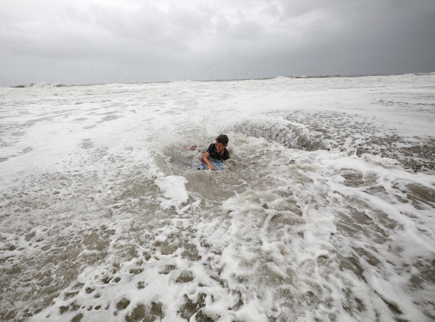
The west coast of Florida faces “the multiple threats of a landfalling hurricane or tropical storm,” said Dennis Feltgen, a meteorologist for the National Weather Service, listing the heavy rainfall, storm surge and possible tornadoes in the forecast.

“One is of course the wind, which could be at the very least gusting to hurricane force, and sustained tropical storm force winds. That’s enough to do some damage,” Feltgen said.

Florida Governor Ron DeSantis declared a state of emergency in 13 counties in Eta’s path on Wednesday and requested that the Federal Emergency Management Agency (FEMA) declare a pre-landfall state of emergency for those counties as well, to mobilize resources.

The storm surge from Eta was expected to affect southern and western Florida and the Florida Keys on Wednesday and Thursday. The state’s west coast was under a storm surge watch on Wednesday from the Suwanee River to Bonita Beach, including Tampa Bay, where the water could rise up to 5 feet.

“These swells are likely to cause life-threatening surf and rip current conditions,” the NHC said in an advisory.

Tampa International Airport said on Twitter it would suspend operations at 3 p.m. on Wednesday due to the impending storm.

Parts of Broward County, on Florida’s east coast, were still severely flooded on Wednesday, with lakes having overflowed and residential streets submerged. Rainfall totals from Eta could add up to 20 inches in some parts of South Florida, the NHC said.

(Reporting by Gabriella Borter; Editing by Bernadette Baum and Steve Orlofsky)

Storm-weary U.S. offshore energy firms prep for massive hurricane

By Erwin Seba

HOUSTON (Reuters) – Oil and gas workers withdrew en masse from U.S. offshore production facilities and onshore refineries began preparations on Wednesday as Hurricane Delta was forecast to grow into a powerful storm over the Caribbean on its way to the Gulf of Mexico.

Delta’s winds declined to 105 miles per hour (169 kph) as it tore across Mexico’s Yucatan peninsula early Wednesday. It is expected to enter the Gulf of Mexico and re-intensify into a Category 3 storm, the National Hurricane Center said.

Oil producers had evacuated 57 production facilities in the U.S. Gulf of Mexico by Tuesday and halted 540,000 barrels per day of oil and 232 million cubic feet per day of natural gas production. The region accounts for about 17% of U.S. oil output.

Onshore energy facilities and export ports began securing operations. Royal Dutch Shell Plc was preparing three refineries in Convent, Geismar and Norco, Louisiana, for Delta’s arrival. Louisiana Offshore Oil Port, the sole deep water port on the Gulf of Mexico, halted seaborne exports and imports.

After weakening over the Yucatan, Delta is expected to re-strengthen and grow into a massive storm. A “life-threatening storm surge and strong winds are likely over a large portion of the northwestern and northern Gulf coast,” the NHC said.

Energy prices were mixed. Natural gas futures were up nearly 2% on storm shut-ins and export disruptions. U.S. crude oil and gasoline futures each fell about 3%.

Delta is expected to strike the U.S. Gulf Coast on the weekend as the 10th named storm to make a U.S. landfall this year, eclipsing a record that has held since 1916.

Oil companies have had to evacuate workers repeatedly this year with departures and returns complicated by pandemic related quarantines and virus testing for offshore staff.

Delta’s evacuations were at least the sixth time that some companies have had to remove staff and curtail production since June.

W&T Offshore Inc, one of the smaller Gulf of Mexico producers, estimated the storms cost it 9,000 barrels of oil and gas per day in the latest quarter, more than a fifth of its targeted output.

Phillips 66 said Delta would delay the restart of its Lake Charles refinery, a Louisiana plant shut by August’s Hurricane Laura. A second plant, on the Louisiana coast, has remained closed since a mid-September storm for maintenance.

Shell, the largest Gulf of Mexico offshore oil producer by volume, evacuated staff from nine facilities and Chevron Corp evacuated and shut production on all its Gulf of Mexico platforms. BP Plc, BHP, Occidental Petroleum Corp, and Murphy Oil pulled workers out and halted some production.

(Reporting by Erwin Seba; writing by Gary McWilliams; Editing by Leslie Adler and Marguerita Choy)

Hurricane Delta weakens before landfall near Mexico’s Cancun

By Anthony Esposito

CANCUN, Mexico (Reuters) – Hurricane Delta rapidly lost strength before landfall near top Caribbean getaway Cancun on Wednesday, potentially saving the area’s hotels, condos and Mayan indigenous villages from an onslaught threatened when it was a menacing Category 4 storm.

Delta had weakened to Category 2 on the five-step Saffir-Simpson scale of intensity, with winds of 110 miles per hour (175 km per hour), by the time it hit the coast close to Puerto Morelos, a fishing village popular with tourists.

Cancun scrambled to shutter shops and evacuate tourists from beach hotels on Tuesday as Delta rapidly gathered strength over the warm Caribbean and looked to be one of the strongest hurricanes to threaten Cancun in years.

Even as a weaker storm, Delta’s arrival is a blow to Mexican efforts to revive tourism in the surrounding beach-lined state of Quintana Roo, where the industry has been battered by the coronavirus pandemic.

“I want to go home, this is crazy,” said Dee Harris, a 29-year-old from Michigan who came to Cancun with his partner and had been due to leave before the storm led to the cancellation of their flight. “The vacation was good before this.”

Delta is also disrupting the oil industry, with companies shutting down offshore production platforms and withdrawing workers.

Peak sustained winds of 84 mph (135 km/h) were recorded at a weather station in Cancun, which is about 24 miles (38.5 km) from snorkeling spot Puerto Morelos close to the eye of the storm.

Delta was expected to pass through Quintana Roo in 10-14 hours, state governor Carlos Joaquin said.

“Hopefully, that speed means it won’t do us so much damage,” Joaquin told Mexican radio.

Slow-moving hurricanes often do more destruction than those with faster lateral movement because they have more time to unleash their force on structures.

Delta is expected to lose some wind power over the peninsula before gathering strength again in the Gulf of Mexico.

On Tuesday, residents queued at supermarkets to stock up on provisions in anticipation of disruptions, while the state government readied shelters that need extra space due to coronavirus social-distancing requirements.

Officials ordered the evacuation of Cancun’s hotel zone and other coastal areas, while shop workers boarded up windows.

A hurricane watch was in place from the beach town of Tulum westwards, including Cozumel.

Water levels could rise by up to 9 feet (3 m) over normal tide conditions due to Delta, the NHC said.

The Yucatan peninsula had already taken a hit at the weekend from Hurricane Gamma, a smaller storm that damaged property and forced restaurants and other attractions to close.

(Writing by Frank Jack Daniel; Editing by Nick Zieminski)

Two storms head for U.S. Gulf in rare hurricane season event

By Liz Hampton

(Reuters) – A pair of tropical cyclones forecast to become hurricanes early next week are headed for the U.S. Gulf Coast and will spin over the Gulf’s warm waters simultaneously, a rare weather event that could cause massive disruption as they make landfall.

The last time two cyclones entered the U.S. Gulf of Mexico was in 1959, according to meteorologists interviewed by Reuters, and there have only been a handful of other occasions when two storms entered the Gulf simultaneously. In 1933, a Category 3 hurricane and moderate tropical storm hit the U.S. Gulf of Mexico, but there haven’t been records of two hurricanes in the Gulf of Mexico at the same time.

Tropical Storm Laura and a separate tropical depression brewing near Honduras could make landfall as hurricanes next week in an area spanning Texas to the Florida Panhandle, according to the National Hurricane Center.

Meteorologists say there is still a lot of uncertainty around the systems and how they develop and move in coming days, particularly as they cross land.

Both storms currently look on track to remain separate, however, any interaction between the two could change their intensity or trajectory, said Dan Kottlowski of AccuWeather. It is unlikely they would combine, he added.

“More than likely one will become stronger, and inflict more vertical wind shear causing the other to weaken,” Kottlowski. “But if they stay of equal strengthen, then they will probably prevent each other from getting really strong.”

In some cases when storms interact, they can orbit each other and the speed of one cyclone could accelerate the other, part of something known as the “Fujiwhara effect,” said David Streit of Commodity Weather Group.

Tropical Storm Laura, which is currently east of the Antilles, was upgraded from a depression on Friday and currently has sustained winds of 45 miles per hour, according to the NHC. Laura is forecast to make landfall as a hurricane on Wednesday in an area spanning Louisiana to the Florida panhandle.

Tropical Depression 14, which would be named Marco if it strengthens, is on track to make landfall on Tuesday near the Texas and Louisiana border. It would arrive around the three-year anniversary of Hurricane Harvey, which dumped a record 50 inches of rain on parts of Houston in August 2017 and caused billions of dollars in damage.

“Tropical Depression 14 doesn’t look robust right now, but it looks to be in an environment conducive to strengthening,” said Phil Klotzbach, a research scientist at Colorado State University.

AccuWeather’s Kottlowski said that Tropical Depression 14 is likely to become the stronger storm as it is slated to pass over a relatively flat area of the Yucatan Peninsula before entering the warm waters of the Gulf of Mexico, where it can gain strength.

(Reporting by Liz Hampton; Editing by Simon Webb and Aurora Ellis)

Hurricane Dorian hits North Carolina’s Outer Banks

A fallen tree and flood waters sit in a hotel parking lot after Hurricane Dorian swept through, in Wilmington, North Carolina, U.S., September 6, 2019. REUTERS/Jonathan Drake

By Amanda Becker

ELIZABETH CITY, N.C. (Reuters) – Hurricane Dorian made landfall on the Outer Banks of North Carolina on Friday, hitting the beach resort area with powerful winds and battering waves days after reducing parts of the Bahamas to rubble.

The storm, packing 90-mile-per-hour winds (150 km-per-hour) made landfall at Cape Hatteras at about 9 a.m. EDT (1300 GMT), according to the National Hurricane Center.

It lashed the Outer Banks with hurricane-force winds as far as 45 miles (72 km) from the center of the hurricane and sent tropical storm winds farther than 200 miles (320 km) from its center, the NHC said.

It has already dumped up to 10 inches (25 cm) of rain along the coast between Charleston, South Carolina, to Wilmington, North Carolina, about 170 miles (275 km) away, forecasters said.

“The rain is moving up north,” said National Weather Service forecaster Alex Lamers early on Friday. “Even the Raleigh-Durham area inland will get 3 inches today.”

Dorian is expected to push out to sea later on Friday and bring tropical storm winds to Nantucket Island and Martha’s Vineyard, Massachusetts, early on Saturday.

But it will likely spare much of the rest of the East Coast the worst of its rain and wind, before likely making landfall in Canada’s Nova Scotia that night, the NHC said.

“It’s in the process of moving out, going north,” Lamers said.

The howling west flank of Dorian has soaked the Carolinas since early Thursday, flooding coastal towns, whipping up more than a dozen tornadoes and cutting power to hundreds of thousands of people.

Floodwaters rose to a foot (30 cm) or more in parts of the historic South Carolina port city of Charleston, where more than 7 inches (18 cm) of rain fell in some areas, officials said. Another half-inch or more was expected overnight Friday.

More than 330,000 homes and businesses were without power in North Carolina and South Carolina on Friday morning. Power had mostly been restored to thousands of people in Georgia, tracking site poweroutage.us showed.

But as Dorian is expected to pick up speed from its 14 mph (22 kph) crawl on Friday, life-threatening storm surges and dangerous winds remain a threat for much of the area and Virginia, the National Hurricane Center said.

Governors in the region declared states of emergency, shut schools, opened shelters, readied National Guard troops and urged residents to heed warnings, as news media circulated fresh images of the storm’s devastation in the Bahamas.

At least 70,000 Bahamians needed immediate humanitarian relief after Dorian became the most damaging storm ever to hit the island nation.

A city park and playground are inundated with flood waters from Hurricane Dorian in Wilmington, North Carolina, U.S., September 6, 2019. REUTERS/Jonathan Drake

A city park and playground are inundated with flood waters from Hurricane Dorian in Wilmington, North Carolina, U.S., September 6, 2019. REUTERS/Jonathan Drake

In the Carolinas alone, more than 900,000 people had been ordered to evacuate their homes. It was unclear how many did so.

In Kill Devil Hills in the Outer Banks, Mark Jennings decided to ignore the order, lining his garage door with sandbags and boarding up his home with plywood.

The retired firefighter planned to stay put with his wife and two dogs, saying: “We are ready to go. If something happens, we can still get out of here.”

Dorian whipped up at least three tornadoes in the region, officials said. One in North Carolina damaged scores of trailers at a campground in Emerald Isle, but no one was injured, the News & Observer said.

Of at least four storm-related deaths reported in the United States, three were in Orange County, Florida, during storm preparations or evacuation, the mayor’s office said.

In North Carolina, an 85-year-old man fell off a ladder while barricading his home for Dorian, the governor said.

(Reporting by Nick Carey in Charleston, South Carolina, and Amanda Becker in Kill Devil Hills, North Carolina; Additional reporting by Jonathan Allen, Peter Szekely, Matt Lavietes and Scott DiSavino in New York and Rich McKay in Atlanta; Editing by Alison Williams, Chizu Nomiyama and Jonathan Oatis)

Floodwaters rise on Charleston’s streets as Hurricane Dorian skirts U.S. coast

Nathan Piper, 11, is swamped by increasingly rough waves while body surfing as Hurricane Dorian approaches, in Carolina Beach, North Carolina, U.S., September 5, 2019. REUTERS/Jonathan Drake

By Nick Carey and Amanda Becker

CHARLESTON, S.C. (Reuters) – Deserted, rain-lashed streets in Charleston, South Carolina, vanished beneath water on Thursday as Hurricane Dorian churned a few dozen miles offshore after reducing parts of the Bahamas to rubble.

Water pooled a few inches deep near the centuries-old waterfront. In certain low-lying blocks, it rose to a foot or more, as high tide approached and forecasters warned of storm surges of up to 8 feet (2 meters).

John Rivers, 74, and his three children were among the few to be seen in the streets on Thursday. They cleared drains of branches, leaves and debris, using a shovel, a rake and their bare hands.

“We’re giving the water somewhere to go,” Rivers said, sheltering temporarily from the driving rain and gusts of wind under a covered walkway. His daughter Caroline, 12, pulled off her rubber boots one at a time, emptying a stream of water from each. “I see this as a good life lesson for my kids,” Rivers said.

Officials said Thursday afternoon that more than 7 inches (18 cm) of rain had fallen in parts of Charleston.

Dorian was about 50 miles (80 kilometers) off Charleston on Thursday, wavering in strength between a Category 2 and 3 on the five-step Saffir-Simpson wind scale. It was forecast to possibly make landfall in North Carolina late Thursday or early Friday.

Life-threatening storm surges and dangerous winds were possible in much of the coast of South Carolina, North Carolina and Virginia, the National Weather Service said.

Dorian whipped up at least three tornados in the region, officials said. One in North Carolina damaged scores of trailers in a campground in Emerald Isle, but no one was injured, North Carolina’s News & Observer reported.

Governors in the region declared states of emergency, closed schools, opened shelters, readied national guard troops and implored residents to take warnings seriously, as fresh images of the devastation wrought by the storm in the Bahamas earlier this week continued to circulate in the media.

At least 70,000 Bahamians needed immediate humanitarian relief after Dorian became the most damaging storm ever to hit the island nation.

In the Carolinas alone, more than 900,000 people had been ordered to evacuate their homes. It was unclear how many did so.

In Kill Devil Hills, in North Carolina’s Outer Banks, Mark Jennings decided to ignore the order, lining his garage door with sandbags and boarding up his home with plywood.

The retired firefighter planned to stay put with his wife and two dogs: “We are ready to go. If something happens, we can still get out of here.”

FOUR DEATHS IN THE U.S.

At least four storm-related deaths have already been reported. Three people died in Orange County, Florida, during storm preparations or evacuation, according to the Orange County mayor’s office. In North Carolina, an 85-year-old man fell off a ladder while barricading his home for Dorian, the governor said.

More than 210,000 homes and businesses were without power in South Carolina and Georgia early on Thursday, according to local electric companies.

On Charleston’s historic South Battery Street, which runs down to the harbor, Brys Stephens tried to keep the water away from his stately home, built in the veranda-wrapped Southern style that lures crowds of tourists to the city.

He and his family pumped water out of the yard and tried to reattach metal flood gates into the perimeter wall.

“The gates worked pretty well so far and we’ve managed to keep water away from the house,” Stephens said. “But we’ve got another storm surge coming later on, so we’ll see then if it holds.”

(Reporting by Nick Carey in Charleston, South Carolina, and Amanda Becker in Kill Devil Hills, North Carolina; Additional reporting by Jonathan Allen, Peter Szekely, Matt Lavietes and Scott DiSavino in New York; Writing by Jonathan Allen; Editing by Scott Malone and Bernadette Baum)

Storm Barry bears down on New Orleans with ‘extreme rain,’ flooding risk

Tropical Storm Barry is shown in the Gulf of Mexico approaching the coast of Louisiana, U.S. in this July 11, 2019 NASA satellite handout photo. NASA/Handout via REUTERS

By Kathy Finn

NEW ORLEANS (Reuters) – Some residents and visitors prepared to flee New Orleans on Thursday as Tropical Storm Barry closed in and officials warned of “extreme rain” and flooding if the storm makes landfall by early Saturday as the first Atlantic hurricane of 2019.

City officials urged residents to shelter in place rather than evacuate as the storm had maximum sustained winds of 40 miles per hour (64 kph) as of 2 p.m. CDT (1900 GMT) on Thursday, the National Weather Service said.

Forecasters issued a storm-surge warning of up to 6 feet (1.8 m) for a stretch of Louisiana coastline south of already-sodden New Orleans stretching from the mouth of the Atchafalaya River to Shell Beach. Rain was an equal danger, given that the lower Mississippi River, which runs through New Orleans, has been above flood stage for six months.

The lower Mississippi is forecast to peak at 19 feet (5.9 m) on Saturday, the highest it has been since 1950, according to the National Weather Service.

“The more information we get, the more concerned we are that this is going to be an extreme rain event,” Louisiana Governor John Bel Edwards said at an afternoon news conference. “If Tropical Storm Barry becomes a hurricane, it would be the first time we’ve had the hurricane hit the state with rising rivers.”

He said he expected the storm to measure a Category 1, the lowest rung on the five-step Saffir-Simpson scale of hurricane wind strength, when it comes ashore.

The slow-moving storm was located about 90 miles (145 km) south of the mouth of the Mississippi River at 2 p.m., the National Hurricane Center said.

Meteorologists predicted between 10 and 20 inches (25 and 50 cm) of rain would fall on the Gulf Coast on Friday and Saturday from East Texas through New Orleans and the Louisiana coast.

‘CANNOT PUMP OUR WAY OUT’

New Orleans Mayor LaToya Cantrell warned that 48 hours of heavy rainfall could overwhelm the pumps the city uses to fight floodwater, leading to flooding as early as Friday morning.

“We cannot pump our way out of the water levels that are expected to hit the city of New Orleans,” Cantrell said. “We need you to understand this.”

Richard Vasquez packs his car with belongings as Tropical Storm Barry approaches land in Port Sulphur, Louisiana, U.S. July 11, 2019. REUTERS/Jonathan Bachman

Richard Vasquez packs his car with belongings as Tropical Storm Barry approaches land in Port Sulphur, Louisiana, U.S. July 11, 2019. REUTERS/Jonathan Bachman

Water pumps already were working at capacity after heavy rains, she said.

Oil companies have shut a third of offshore Gulf of Mexico production ahead and a coastal refinery was set to shut down due to an evacuation order prompted by the storm, pushing oil and gasoline prices higher.

Cantrell said no official evacuation orders were being issued but urged people to gather supplies, secure their property and shelter in place.

But some in New Orleans, hard hit when Hurricane Katrina swamped the city in 2005 and killed 1,800 across the region, were getting out.

In the city’s Bywater neighborhood a block from the Mississippi River, Betsey and Jack Hazard were preparing to repair a fence around their house and flee with their two small children to Mississippi.

“It’s really the river that has us worried,” said Betsey Hazard, saying she feared it could overtop the nearby levee. “They say that the river won’t flood in New Orleans but we have a 5-year-old and a 10-month-old, and we don’t want to take any chances.”

In the normally bustling French Quarter, popular with tourists, only a couple of tables were occupied at the coffee-and-beignet restaurant Café du Monde.

Kate Clayson of Northampton, England, and her boyfriend Maxx Lipman of Nashville, Tennessee, said they had arrived on Wednesday for a vacation but were planning to depart on Thursday.

“The woman at our Airbnb said the water came up to the first step of our house yesterday so we’ve just decided we’d better get out,” Clayson said.

The storm will become Hurricane Barry if it reaches wind speeds of 74 mph (119 km) as expected when it makes landfall near the mouth of the Mississippi River and just west of New Orleans.

The National Weather Service said the city had received 6 to 9 inches (15 to 23 cm) of rain by Thursday morning, causing dramatic flooding in the area, including on Bourbon Street in the city’s historic French Quarter.

(Additional reporting by Gabriella Borter and Jonathan Allen in New York and Rich McKay in Atlanta; Writing by Scott Malone; Editing by Bill Trott)

Philippines evacuates coastal areas ahead of typhoon Yutu

A general view of the damage after Super Typhoon Yutu hit Saipan, Northern Mariana Islands, U.S., October 25, 2018 in this picture taken through a cracked vehicle window, obtained from social media. Brad Ruszala via REUTERS

MANILA (Reuters) – The Philippines raised storm warning levels on Monday and began evacuating some coastal communities in the path of a typhoon that threatened storm surges, landslides and floods triggered by heavy winds and rain.

Typhoon Yutu, which caused havoc last week with a direct hit on the U.S. Northern Mariana islands, was set to make landfall on Tuesday morning and move across the main island of Luzon before leaving the Philippines 24 hours later, the state weather agency PAGASA said.

By mid-morning on Monday, Yutu was about 400 km (249 miles)east of the mainland and had weakened to sustained wind speeds of 150 km per hour (93 mph), with gusts of 185 kph, from 170 kph recorded a few hours earlier.

That was less intense than four days ago, when as a super typhoon with wind speeds of over 270 kph barreled through the Marianas, a U.S. Western Pacific archipelago of 52,000 people, tearing off roofs, overturning vehicles and cutting off power and water.

Authorities in Isabela and Cagayan provinces started moving residents in coastal towns to evacuation centers while the mountainous Cordillera region was put on red alert for landslides.

Three provinces in north Luzon were elevated to warning signal 3 on the severity scale of 5, and 28 more put on the earliest warnings of 1 and 2, with strong winds and rains expected later on Monday.

Known locally as Rosita, the typhoon will be the 18th to hit the Philippines this year and comes six weeks after super typhoon Mangkhut tore across Luzon, triggering landslides that killed dozens of people and damaged about $180 million of crops.

School classes were suspended in at least five provinces and fishermen in Luzon and the eastern seaboard advised not to go to sea, with warnings of storm surges of up to three metres in six provinces.

All boat services in the port city of Batangas, about 83 km (52 miles) south of Manila, were suspended on Monday.

About half of the Philippines’ 105 million population live in the Luzon region. The country is hit by an average 20 typhoons each year.

(Reporting by Martin Petty and Karen Lema; editing by Darren Schuettler)

Typhoon leaves flooding, four dead in Japan before moving out to sea

A collapsed road is seen following torrential rain caused by typhoon Lan in Kishiwada, Japan in this photo taken by Kyodo on October 23, 2017. Mandatory credit Kyodo/via REUTERS

By Elaine Lies

TOKYO (Reuters) – A rapidly weakening typhoon Lan made landfall in Japan on Monday, setting off landslides and flooding that prompted evacuation orders for tens of thousands of people, but then headed out to sea after largely sparing the capital, Tokyo.

Four people were reported killed, hundreds of plane flights canceled, and train services disrupted in the wake of Lan, which had maintained intense strength until virtually the time it made landfall west of Tokyo in the early hours of Monday.

At least four people were killed, including a man who was hit by falling scaffolding, a fisherman tending to his boat, and a young woman whose car had been washed away by floodwaters.

Another casualty was left comatose by injuries and a man was missing, NHK public television said. Around 130 others suffered minor injuries.

Rivers burst their banks in several parts of Japan and fishing boats were tossed up on land. A container ship was stranded after being swept onto a harbor wall but all 19 crew members escaped injury.

Some 80,000 people in Koriyama, a city 200 km (124 miles) north of Tokyo, were ordered to evacuate as a river neared the top of its banks, NHK said, but by afternoon water levels were starting to fall. Several hundred houses in western Japan were flooded.

“My grandchild lives over there. The house is fine, but the area is flooded, and they can’t get out,” one man told NHK.

Lan had weakened to a category 2 storm when it made landfall early on Monday, sideswiping Tokyo, after powering north for days as an intense category 4 storm, according to the Tropical Storm Risk monitoring site.

Lan is the Marshall islands word for “storm”.

By Monday afternoon the storm had been downgraded to a tropical depression and it was in the Pacific, east of the northernmost main island of Hokkaido, the Japan Meteorological Agency said.

Around 350 flights were canceled and train services disrupted over a wide area of Japan, although most commuter trains were running smoothly in Tokyo.

Toyota Motor Corp canceled the first shift at all of its assembly plants but said it would operate the second shift as normal.


(Additional reporting by Junko Fujita and Naomi Tajitsu; Editing by Michael Perry & Simon Cameron-Moore)