Indonesia gets shaken by 7.0 Earthquake

Mathew 24:7 For nation will rise against nation, and kingdom against kingdom, and there will be famines and earthquakes in various places.

Important Takeaways:

  • 7.0 magnitude earthquake shakes Indonesia’s main island
  • A strong earthquake has shaken parts of Indonesia’s main island of Java and tourist island of Bali, causing panic but there are no immediate reports of serious damage or casualties
  • The U.S. Geological Survey said the magnitude 7.0 quake was centered 96.5 kilometers (59.8 miles) north of Tuban, a coastal city in East Java province, at a depth of 594 kilometers (369 miles).
  • Indonesia’s Meteorology, Climatology and Geophysical Agency said there was no danger of a tsunami but warned of possible aftershocks. The agency put a preliminary magnitude at 6.6. Variations in early measurements are common.

Read the original article by clicking here.

Indonesia tells residents near coast to get to high ground after tsunami alert

People gather outside an office building following an earthquake hit in Jakarta, Indonesia, August 2, 2019 in this photo taken by Antara Foto. Antara Foto/Dwi Prasetya/ via REUTERS

By Ed Davies and Jessica Damiana

JAKARTA (Reuters) – Indonesian authorities urged coastal-dwellers to head for higher ground on Friday after a tsunami warning with potential for waves up to three meters (10 feet) following a powerful earthquake off the islands of Sumatra and Java.

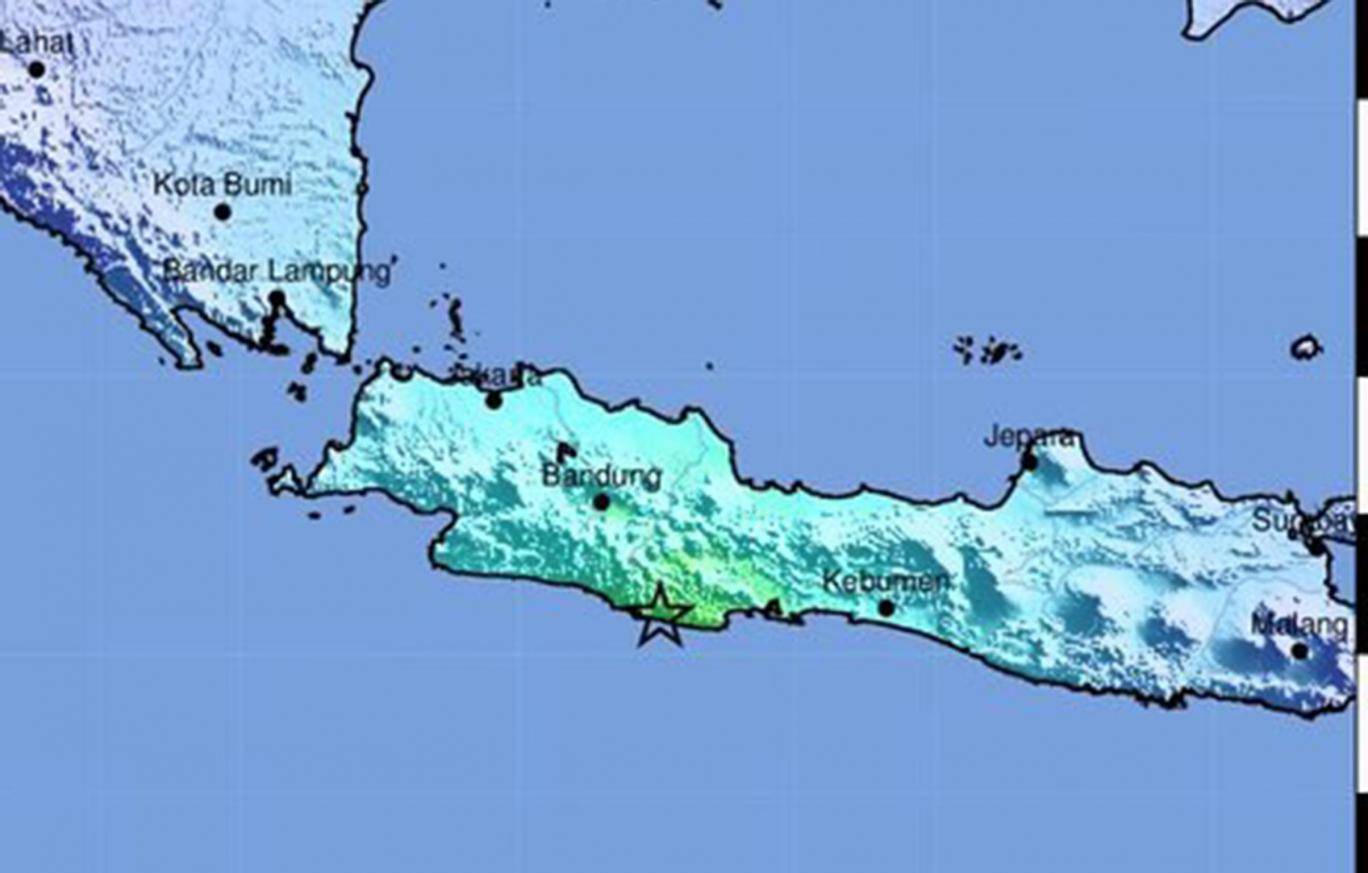
The U.S Geological Survey put the epicenter in the Indian Ocean about 227 km (141 miles) from Teluk Betung city on Sumatra with an initial magnitude of 7 that was later lowered to 6.8.

There were no immediate reports of damage or casualties, but strong tremors were felt in Jakarta, the capital, prompting people to run out of office buildings.

“It was so scary,” said Gustiani Pratiwi, carrying two children out of an apartment block in Jakarta after feeling the quake strongly.

Indonesia is situated on the so-called Pacific Ring of Fire, which is frequently hit by earthquakes and sometimes accompanying tsunamis.

The most devastating in recent Indonesian history was on Dec. 26 in 2004, when a magnitude 9.5 quake triggered a massive tsunami that killed around 226,000 people along the shorelines of the Indian Ocean, including more than 126,000 in Indonesia.

Indonesia’s geophysics agency said it would keep monitoring for a potential tsunami until at least 21:35 pm (1435 GMT) and warned residents to stay alert.

The tsunami risk was in southern parts of Banten province in Java and Lampung province in Sumatra, it said.

“Please look for higher ground at least 10 meters (33 feet) high,” agency chief Dwikorita Karnawati told a news conference.

TV footage showed passengers at Jakarta’s international airport rushing out of a terminal building, but authorities later said the airport was operating normally.

The quake could also be felt in other cities such as Yogyakarta on Java island.

One social media video showed panicked guests dashing out past a hotel swimming pool in Tasikmalya on Java island.

Last year, a tsunami hit the city of Palu in Sulawesi island, killing thousands, while a crater collapse at the Anak Krakatau volcano triggered a tsunami that killed at least 430 people in an area near the latest quake.

At Carita beach in Banten, which was affected by the Anak Krakatau quake, a resident described the alarm in the area.

“We are panicking a lot,” Sandi, a resident of Carita beach, told Metro TV by telephone.

(Reporting by Ed Davies and Jessica Damiana; Editing by Clarence Fernandez and Andrew Cawthorne)

Volcano-triggered tsunami kills at least 43 in Indonesia, injures hundreds

Residents sit inside a mosque as they evacuated following high waves and the eruption of Anak Krakatau volcano at Labuan district in Pandeglang regency, Banten province, Indonesia, December 22, 2018 in this photo taken by Antara Foto. Picture taken December 22, 2018. Antara Foto/Muhammad Bagus Khoirunas/ via REUTERS

By Jessica Damiana

JAKARTA (Reuters) – A tsunami killed at least 43 people on the Indonesian islands of Java and Sumatra and injured hundreds following an underwater landslide caused by a volcanic eruption, the disaster mitigation agency said on Sunday.

Some 584 people were injured and hundreds of homes and other buildings were “heavily damaged” in the tsunami which struck late on Saturday.

On Dec. 26 in 2004, an Indian Ocean tsunami triggered by an earthquake killed 226,000 people in 13 countries, including more than 120,000 in Indonesia.

Endan Permana, head of the agency in Pandeglang, told Metro TV police were providing immediate assistance to victims in Tanjung Lesung in Banten province, a popular tourist getaway not far from the capital, Jakarta, as emergency workers had not arrived in the area yet.

“Many are missing,” Permana said.

The agency said it was still compiling information and there was a “possibility that data on the victims and damage will increase”.

The tsunami was caused by “an undersea landslide resulting from volcanic activity on Anak Krakatau” and was exacerbated by abnormally high tide because of the current full moon, disaster agency spokesman Sutopo Purwo Nugroho said.

According to a statement from the Meteorology, Climatology and Geophysics Agency (BMKG), Krakatau erupted at just after 9 p.m. and the tsunami struck at around 9.30 p.m. on Saturday.

“The tsunami hit several areas of the Sunda Strait, including beaches in Pandeglang regency, Serang, and South Lampung,” the agency said.

Nugroho told Metro TV that tsunamis triggered by volcanic eruptions were “rare” and that the Sunda Strait tsunami had not resulted from an earthquake.

“There was no earthquake, and the Anak Krakatau eruption also wasn’t that big,” Nugroho told Metro TV, noting there were no “significant” seismic tremors to indicate a tsunami was coming.

The Krakatau eruption created a column of volcanic ash estimated to be up 500 meters high.

(Reporting by Gayatri Suroyo, Tabita Diela and Jessica Damiana; Writing by Fergus Jensen; Editing by Nick Macfie)

Strong quake hits Indonesia’s Java, kills three

Map of Indonesia

JAKARTA (Reuters) – A powerful magnitude 6.5 earthquake struck the island of Java in Indonesia just before midnight on Friday, with authorities reporting three deaths and damage to hundreds of buildings.

The U.S. Geological Survey said the epicenter of the quake was located at a depth of 92 km (57 miles), about 52 km southwest of Tasikmalaya.

Indonesia’s national disaster management agency said the quake activated early tsunami warning systems in the south of Java, prompting thousands to evacuate from some coastal areas, but no tsunami was detected.

Tremors were felt in central and west Java.

Sutopo Purwo Nugroho, a spokesman for the disaster agency, said in a press briefing on Saturday three people had been killed, seven injured and hundreds of buildings damaged, including schools, hospitals, and government buildings in West and Central Java.

Dozens of patients had to be helped to safety from a hospital in Banyumas and were given shelter in tents, he said.

He posted on his Twitter page photos of people scouring collapsed buildings.

The quake swayed buildings for several seconds in the capital Jakarta. Some residents of high rise apartment buildings in central Jakarta quickly escaped their apartments, local media reported.

Indonesia’s meteorology and geophysics agency said a magnitude 5.7 quake early on Saturday also struck south of West Java. It said the quake did not have tsunami potential.

Java, Indonesia’s most densely populated island, is home to more than half of its 250 million people.

(Reporting by Kanupriya Kapoor, Agustinus Da Costa and Fransiska Nangoy; Writing by Ed Davies; Editing by Hugh Lawson & Shri Navaratnam)