Storm Michael expected to hit Florida as a hurricane midweek

A satellite image of Tropical Storm Michael taken Monday. NOAA/via REUTERS

By Rich McKay and Jon Herskovitz

(Reuters) – Tropical Storm Michael is on track to hit the Florida Panhandle midweek as a Category 2 hurricane packing 100 miles per hour (160 kmh) or stronger winds, the U.S. National Hurricane Center (NHC) said early Monday in an advisory.

The tropical storm is expected to swell into a Category 1 hurricane as soon as Monday night or early Tuesday as it rolls into the U.S. Gulf of Mexico, with winds of 70 mph, as of 5 a.m. eastern time, forecasters said, just shy of being named a hurricane.

A storm is designated a Category 1 hurricane if it reaches speeds of 74 mph (119 km) or more, and a Category 2 hurricane at 96 mph (154 km) or more on the Saffir-Simpson hurricane wind scale.

Florida Gov. Rick Scott declared a state of emergency in more than 20 counties along the Florida Panhandle and Big Bend on Sunday and has put more than 5,000 National Guard soldiers on alert.

“Our state understands how serious tropical weather is and how devastating any hurricane of tropical storm can be,” Scott said in a statement.

He advised Gulf Coast residents to prepare for possible evacuation orders.

Michael battered parts of Mexico and Cuba with powerful winds and drenching rains on Sunday and into early Monday as it churned in the Caribbean.

The storm moved north on a path between Cozumel in southeastern Mexico and the western tip of Cuba, the Miami-based hurricane center said.

A hurricane watch has been issued from the Alabama-Florida border eastward to the Suwanee River, Florida.

Outer bands from Michael are expected produce as much as 4 inches (10 cm) of rain through Tuesday in the Florida Keys, one of several areas in the state devastated by Hurricane Irma last year.

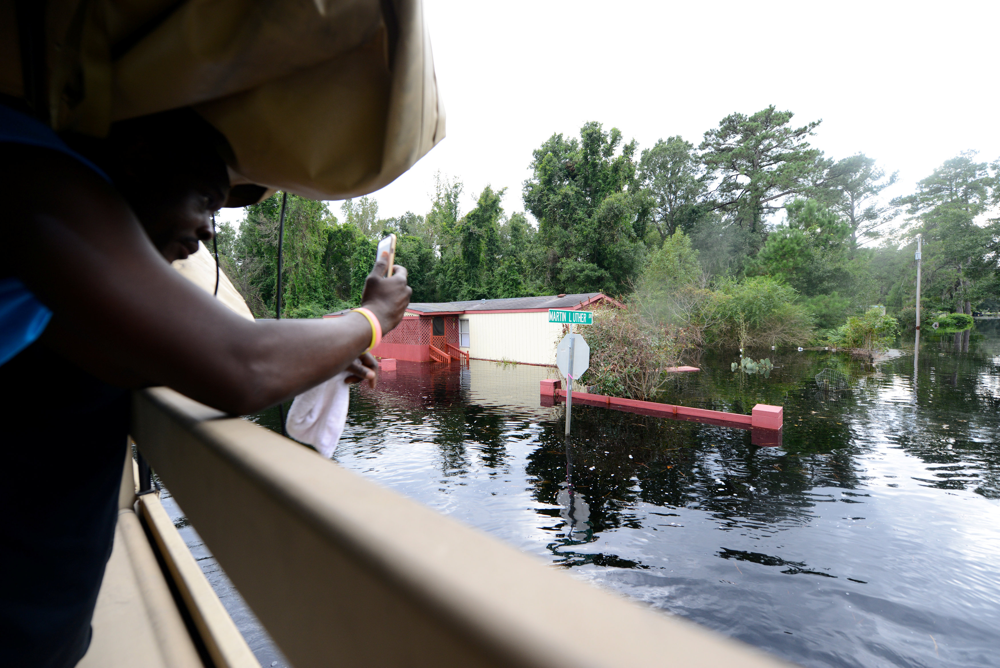
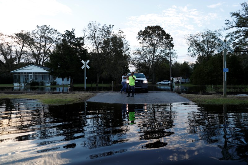
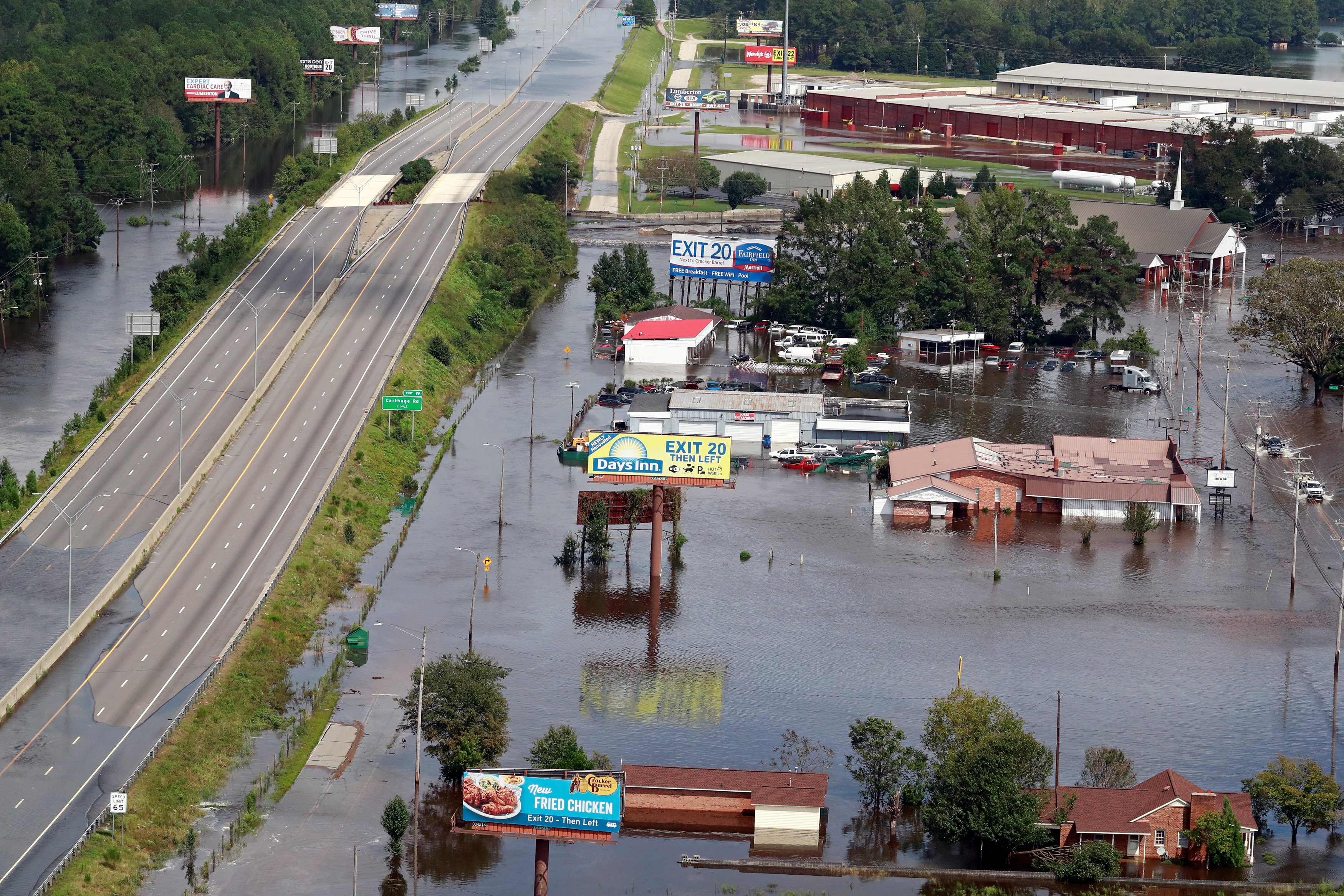
After hitting Florida, the storm is then forecast to move northeast along the Atlantic Coast and batter the Carolinas, which are still recovering from Hurricane Florence last month. That hurricane killed at least 50 people and caused billions of dollars in damage.

The Commodity Weather Group said on Sunday some oil rigs in the gulf area may be evacuated as a precaution, which may slow down operations but was not likely cause much interruption.

The Gulf of Mexico is home to 17 percent of U.S. crude oil and 5 percent of natural gas output daily, according to the U.S. Energy Information Administration.

More than 45 percent of the nation’s refining capacity is located along the U.S. Gulf Coast, which also is home to 51 percent of total U.S. natural gas processing capability.

(Reporting by Rich McKay in Atlanta and Jon Herskovitz in Austin, Texas; Editing by Raissa Kasolowsky)

Florence-triggered flooding washes into South Carolina

U.S. Army Pfc. Marlen Squire, of the South Carolina National Guard, assists in evacuating local residents from floodwaters as a result of Hurricane Florence in Dongola, South Carolina, U.S. September 24, 2018. Staff Sgt. Jorge Intriago/U.S. Army National Guard/Handout via REUTERS

By Harriet McLeod and Gene Cherry

CHARLESTON, S.C./RALEIGH, N.C. (Reuters) – Thousands of people in the Georgetown, South Carolina area were urged to leave as rivers inundated by Hurricane Florence rainwater threatened on Wednesday to submerge neighborhoods under 10 feet of water.

Georgetown, which sits at the confluence of the Waccamaw, Great Pee Dee and Sampit rivers, was largely spared the initial fury of Florence, which came ashore on Sept. 14 as a Category 1 hurricane and killed 46 people in three states.

But the port city of more than 9,000 people stands in the path of what the National Weather Service says could be significant flooding as water dumped by the storm system drains to the ocean.

Between 6,000 and 8,000 people have been exhorted to leave, but it was not clear how many had done so as of Tuesday evening, said Randy Akers, deputy public information officer for Georgetown County.

Parts of Georgetown could be submerged in up to 10 feet (3 meters) of water in the coming days as the Pee Dee and Waccamaw rivers overrun their banks, the National Weather Service said, adding that the deluge threatened to cut off highways and isolate communities.

“Be very vigilant,” Georgetown County Emergency Management Director Sam Hodge told residents on Facebook. “When you see the water start to rise, that is when it is time to take action.”

High waters surround homes and businesses in the small town of Bucksport, South Carolina, U.S. as rivers continue to rise and flooded areas expand as a result of Hurricane Florence, September 24, 2018. Staff Sgt. Jorge Intriago/U.S. Army National Guard/Handout via REUTERS

High waters surround homes and businesses in the small town of Bucksport, South Carolina, U.S. as rivers continue to rise and flooded areas expand as a result of Hurricane Florence, September 24, 2018. Staff Sgt. Jorge Intriago/U.S. Army National Guard/Handout via REUTERS

COAL ASH POND COULD FLOOD

In neighboring Conway County, the Waccamaw, which was already well above flood stage on Tuesday, could inundate a coal ash pond that holds more than 200,000 tons of toxic ash, according to Santee Cooper, South Carolina’s state-owned electric and water utility.

Santee Cooper said it has removed more than 1 million tons of coal ash, which can contaminate water and harm fish and wildlife, from the site in the past few years.

The Waccamaw was forecast to crest on Thursday at 22 feet in Conway and at 21.2 feet in Georgetown, a representative with the South Carolina Emergency Management Division said.

The potential flood zone encompasses roughly 3,500 homes in Georgetown, 37 miles (60 km) south of Myrtle Beach, and the coastal resort community of Pawleys Island where as many as 8,000 people live, Georgetown County spokeswoman Jackie Broach-Akers said.

Authorities warned residents in harm’s way with recorded telephone messages and home visits. The county opened two emergency shelters on Monday, and hotels in nearby Myrtle Beach were offering discounts to evacuees. Public schools were closed until further notice.

FILE PHOTO: Water from the flooded Waccamaw River surrounds a house in the aftermath of Hurricane Florence now downgraded to a tropical depression in Conway, South Carolina, U.S. September 19, 2018. REUTERS/Randall

FILE PHOTO: Water from the flooded Waccamaw River surrounds a house in the aftermath of Hurricane Florence now downgraded to a tropical depression in Conway, South Carolina, U.S. September 19, 2018. REUTERS/Randall Hill

Crews worked to erect temporary dams on either side of U.S. Highway 17, the main coastal route through the area, and National Guard engineers were installing a floating bridge at Georgetown in case the highway is washed out at the river.

Florence dumped 30 to 40 inches (75 to 100 cm) of rain on Wilmington, North Carolina, alone.

Insured losses from Hurricane Florence will range from $2.8 billion to $5 billion, according to RMS, a risk modeling and analytics firm.

(Additional reporting by Brendan O’Brien in Milwaukee and Dan Whitcomb in Los Angeles; Writing by Dan Whitcomb; Editing by Bill Trott, Leslie Adler and Cynthia Osterman)

Waterways rise in South Carolina, residents told to leave

Flooding is seen in and around Wilmington, North Carolina, U.S., September 19, 2018 in this picture obtained from social media on September 21, 2018. ALAN CRADICK, CAPE FEAR RIVER WATCH/via REUTERS

By Harriet McLeod and Gene Cherry

CHARLESTON, S.C./RALEIGH, N.C. (Reuters) – Authorities urged thousands of people to leave their homes around the city of Georgetown, South Carolina as water dumped by long-departed Hurricane Florence surged down rivers and threatened to bring devastating floods.

Water levels were still rising early on Tuesday, said emergency services there, more than a week after the storm first made landfall on the U.S. Atlantic coast and killed 46 people mostly in North Carolina.

Parts of Georgetown could be submerged in up to 10 feet (3 meters) of floodwaters in the next few days as the Pee Dee and Waccamaw rivers overran their banks, said the National Weather Service.

The deluge threatened to cut off highways and isolate communities, they added.

“If the flood map … shows you are in an affected area, you need to leave,” Georgetown County Sheriff Lane Cribb said on Monday. “Your property can be replaced, but your life can’t.”

Authorities were sending recorded telephone messages to residents in harm’s way and will go door-to-door over the next two days, Georgetown County spokeswoman Jackie Broach-Akers said.

The potential flood zone encompasses some 3,500 homes in Georgetown, 37 miles (60 km) south of Myrtle Beach, and the coastal resort community of Pawleys Island where as many as 8,000 people live, Broach-Akers said.

FLORENCE IMPACT “STILL WITH US”

The county opened two emergency shelters on Monday, and hotels outside the flood zone in nearby Myrtle Beach were offering discounts to evacuees. Public schools will be closed until further notice, Broach-Akers said.

State transportation crews were working to erect temporary dams on either side of U.S. Highway 17, the main coastal route through the area, and National Guard engineers were installing a floating bridge at Georgetown in case the highway is washed out at the river.

The National Weather Service said flooding from Florence would likely persist in coastal parts of the Carolinas for days as the high-water crest of numerous rivers keeps moving downstream toward the ocean.

In North Carolina, Governor Roy Cooper said on Monday that seven rivers in the southeast part of the state were at major flood stages and three others at moderate flood stages.

“Florence is gone but the storm’s devastation is still with us,” Cooper said in a statement.

The storm dumped 30 to 40 inches (75 to 100 cm) of rain on Wilmington, North Carolina, alone after making landfall nearby on Sept. 14. The storm moved northwest before turning back east and becoming a post-tropical cyclone over West Virginia three days later.

Insured losses from Hurricane Florence will range from $2.8 billion to $5 billion, RMS, a risk modeling and analytics firm, said on Monday.

(Reporting by Brendan O’Brien in Milwaukee; Editing by Andrew Heavens)

Rising flood waters from Florence menace Carolinas – kills at least 32

Houses sit in floodwater caused by Hurricane Florence, in this aerial picture, on the outskirts of Lumberton, North Carolina, U.S. September 17, 2018. REUTERS/Jason Miczek

By Ernest Scheyder and Patrick Rucker

WILMINGTON/FAYETTEVILLE, N.C. (Reuters) – Rising flood waters threatened communities across the Carolinas on Tuesday as storm Florence hit the U.S. Northeast with heavy rains and tornadoes after killing at least 32 people.

Widespread flooding has already reached roofs, turned highways into rivers and left thousands to be saved by rescue workers. Waterways are expected to keep rising on Tuesday in places like Fayetteville, North Carolina, a city of 200,000 in the southern part of the state, according to the National Weather Service (NWS).

People take cell phone photos of the flood waters in the aftermath of Hurricane Florence in Fair Bluff, North Carolina, U.S. September 18, 2018. REUTERS/Randall Hill

People take cell phone photos of the flood waters in the aftermath of Hurricane Florence in Fair Bluff, North Carolina, U.S. September 18, 2018. REUTERS/Randall Hill

At least 32 people have been killed since Florence came ashore as a hurricane on Friday, including 25 in North Carolina and six in South Carolina. One person was killed when at least 16 tornadoes developed from Florence on Monday in Virginia, where dozens of buildings were destroyed, the NWS reported.

The dead included a 1-year-old boy swept from his mother as they tried to escape their car amid floodwaters. The woman had driven around barricades to reach a closed road, the sheriff’s office in Union County, near North Carolina’s border with South Carolina, said on Facebook.

“Flooding is still going to be a concern into the weekend and into next week,” NWS meteorologist Hal Austin said, noting there is a chance of rain for the region on Tuesday and Wednesday. “No more water, not even a drop, please.”

With 1,500 roads closed across North Carolina, fire and rescue crews were waiting to go into many areas to assist with structural damage after Florence dumped up to 36 inches (91 cm) of rain on the state since Thursday.

“Road conditions are still changing,” the North Carolina Department of Transportation said on Twitter on Tuesday. “What’s open now may become impassable.”

All told, more than 8 trillion gallons of rain fell on North Carolina, NWS said.

Forecasters warned heavy rains could cause flash flooding in the U.S. Northeast on Tuesday. As much as 6 inches (15 cm) of rain was possible in parts of the region, the NWS said. The storm was now passing through the mid-Atlantic and was about 100 miles (165 km) northwest of Philadelphia, according to the NWS.

It is expected to keep producing heavy rain over Pennsylvania into southern New England.

An aerial picture shows a flooded Interstate 95 (I-95) after Hurricane Florence in Lumberton, North Carolina, U.S. September 17, 2018. REUTERS/Jason Miczek

An aerial picture shows a flooded Interstate 95 (I-95) after Hurricane Florence in Lumberton, North Carolina, U.S. September 17, 2018. REUTERS/Jason Miczek

STRUCTURAL DAMAGE

Thousands of rescues have taken place in the Carolinas and more than 650 people were taken to safety in and around Wilmington, North Carolina, said Barbi Baker, a spokeswoman for New Hanover County. The city took a direct hit when Hurricane Florence came ashore and has been largely cut off since then due to storm surges and flooding from the Cape Fear River.

More than 340,000 customers were without power on Tuesday morning, according to power companies, down from a peak of nearly 1 million outages.

North Carolina had deployed about 2,000 boats and 36 helicopters to help people stranded in floods, the state’s director of emergency management, has said.

The Coast Guard said it had 26 helicopters and 11 aircraft looking for people in trouble.

Property damage from the storm is expected to total at least $17 billion to $22 billion but that forecast could be conservative depending on further flooding, risk management firm Moody’s Analytics said.

A power outage at a wastewater treatment plant in Wilmington caused partially treated sewage water to be released into the Cape Fear River, said Reggie Cheatham, director of the U.S. Environmental Protection Agency’s Office of Emergency Management.

Sewage releases in the Neuse River were reported as well as overflows at several hog “lagoons,” used to store waste from pig farms.

(Additional reporting by Bernie Woodall in Miami; Brendan O’Brien in Milwaukee: Jessica Resnick-Ault and Barbara Goldberg in New York; Anna Mehler Paperny in North Carolina; and Rich McKay in Atlanta; Writing by Bill Trott; Editing by Janet Lawrence)

Storm Florence’s drenching rains kill 23 in the Carolinas

Members of the Coast Guard launch rescue boats into the neighborhood of Mayfair in the flood waters caused by Hurricane Florence in Lumberton, North Carolina, U.S. September 16, 2018. REUTERS/Jason Miczek

By Ernest Scheyder and Patrick Rucker

WILMINGTON/FAYETTEVILLE, N.C. (Reuters) – Deeper flooding loomed in the hours and days ahead from rivers in the Carolinas swollen by Tropical Depression Florence, which has killed 23 people, even if rain-weary residents got a brief glimpse of sunshine on Monday.

The slow-moving storm, a hurricane when it hit the North Carolina coast, has dumped up to 36 inches (91 cm) of rain on the state since Thursday, displacing thousands. The flooding could persist for several weeks in some areas.

The coastal city of Wilmington remained cut off by floodwaters from the Cape Fear River on Monday. Further inland, the same river, running through Fayetteville, a city of 200,000, was expected to reach major flood levels later on Monday, and would not crest until Tuesday.

Florence was headed through Virginia and toward New England and flash flood watches extended from Maryland through New York and southern New England.

In the Carolinas, the National Weather Service continued to warn people the floods were worsening.

“The worst is yet to come,” as river levels rise to historic levels, said Zach Taylor, an NWS meteorologist. “The soil is soaked and can’t absorb any more rain so that water has to go somewhere, unfortunately.”

Major rivers are expected to remain flooded for the next two to three weeks, said Steve Goldstein, National Oceanic and Atmospheric Administration liaison to the U.S. Federal Emergency Management Agency (FEMA).

The death toll from Florence, which came ashore in North Carolina on Friday, rose to 23 on Monday.

The dead included a 1-year-old boy who was swept away from his mother as they tried to escape their car amid floodwaters. The woman had driven around barricades to get on a closed road, the sheriff’s office in Union County, near North Carolina’s border with South Carolina, said on Facebook.

North Carolina officials reported 1,200 road closures, including a stretch of Interstate 95, a major transportation artery running the length of the U.S. East Coast.

About 509,000 homes and businesses were without electricity on Monday in North and South Carolina and surrounding states.

POWER OUTAGES, BLOCKED ROADS

The sun appeared in some areas for the first time in days, allowing some people who had been forced to leave their homes to return home to assess damage.

Eric Tryggeseth, 59, found his home in Leland, North Carolina, without power and with a tree lying in his front yard. He had been evacuated a day before by troops in a truck.

“The floodwaters were rising so I figured I better get out of there,” he said. “I can’t thank the first responders enough.”

There were currently 2,000 federal workers working on storm response, supporting state efforts, said Tom Fargione, FEMA Federal Coordinating Officer, during a press conference.

Sean Adams, 29, a contractor from Leland, said his home suffered only minor damage but he had no idea when power might be restored.

With so many roads in and out of the region flooded, he could not access supplies to help start rebuilding.

“We really can’t get much done right now. It’s getting frustrating,” he said.

The storm killed 17 people in North Carolina, including a mother and child hit by a falling tree, state officials said. Six people died in South Carolina, including four in car accidents and two from carbon monoxide from a portable generator.

(Reporting by Patrick Rucker and Ernest Scheyder; Additional reporting by Bernie Woodall in Miami; Jessica Resnick-Ault and Barbara Goldberg in New York; Anna Mehler Paperny in North Carolina; and Rich McKay in Atlanta; Writing by Bill Trott; Editing by Nick Zieminski and Frances Kerry)

Hurricane Lane lashes Hawaii with heavy rain, winds

A chicken hops through floodwaters in Hilo, Hawaii, U.S. August 23, 2018, in this still image from video obtained from social media. Kehau Comilla/via REUTERS

By Jolyn Rosa

HONOLULU (Reuters) – Hurricane Lane, a powerful Category 3 storm, lashed Hawaii on Thursday with high winds and torrential rain, causing flash floods, landslides and raging surf as residents hunkered down to ride out the storm.

The storm spun in the Pacific Ocean about 165 miles (260 km) southwest of Kailua-Kona and nearly 20 inches (51 cm) of rain had fallen on the eastern side of the Big Island of Hawaii, the National Weather Service (NWS) said.

“There’s lots and lots of rain, torrential rain, with a lot of moisture in the atmosphere,” NWS meteorologist Chevy Chevalier said, noting there were reports of 50 miles per hour (80 km/h) wind gusts. “We’re in it now.”

There were no reports of injuries, but roads were closed because of flash floods and landslides in the Pacific island state. Tourists were advised to stay away from a popular attraction on the island of Maui called the Seven Sacred Pools, a scenic cluster of waterfalls and grottos.

“Life threatening flash floods. This is a very dangerous situation. Avoid unnecessary travel,” Governor David Ige said on Twitter.

Evacuations were underway on parts of Molokai and Maui islands while power outages were being reported on social media.

The latest predictions showed the eye of the storm twisting west of the Big Island on Friday morning before glancing past Maui and several other islands later in the day on its way to Oahu. But authorities warned the islands could still expect to be hit hard.

Lane shifted from heading northwest and was headed north at 6 miles per hour as the Category 3 storm on the five-step Saffir-Simpson scale was packing winds of 120 mph (195 kph), the service said in an evening advisory.

“We’re telling everybody to take the storm seriously, make your final preparations, and be prepared to ride out what is going to be a prolonged rain event,” said Andrew Pereira, communications director for the city and county of the state capital Honolulu.

Incoming waves tower over bystanders in Kona, Hawaii, U.S. August 23, 2018 in this still image from video obtained from social media. Ryan Leinback/via REUTER

Incoming waves tower over bystanders in Kona, Hawaii, U.S. August 23, 2018, in this still image from video obtained from social media. Ryan Leinback/via REUTERS

REMEMBERING INIKI

The National Hurricane Center warned storm surges could raise water levels 3 to 5 feet (1 to 1.5 meters) above normal along the western shores of the Big Island and that extreme rainfall could mean “numerous evacuations and rescues.”

Ige has urged residents to set aside a 14-day supply of water, food, and medicine. All public schools, University of Hawaii campuses and non-essential government offices on the islands of Oahu and Kauai were closed at least through Friday.

“We are in our room at Alohilani Resort waiting for Hurricane Lane to arrive,” said Janina Ballali on Twitter. “Hopefully, the hurricane will have mercy with our beloved Oahu.”

Par Pacific Holdings Inc said it had shut its 93,500 barrel-per-day refinery in Kapolei due to the storm.

In Hanalei on Kauai, rain fell Thursday as residents and businesses prepared for the hurricane while tourists continued to shop and dine in places that were still open.

Dave Stewart, owner of Kayak Hanalei, had boarded up the windows on his shop by mid-afternoon and moved the company’s rental kayaks to high ground.

He said he wasn’t taking any chances, having lived through severe flooding on Kauai’s North Shore in April and through Hurricane Iniki in 1992.

“That was total destruction,” he said of Iniki. “Seven out of 10 telephone poles were down, so even if your house was OK, you couldn’t get out.”

Iniki was the most powerful hurricane on record to hit Hawaii, making landfall on Kauai island on Sept. 11, 1992, as a Category 4. It killed six people and damaged or destroyed more than 14,000 homes.

The shelves of a downtown Honolulu Walmart were stripped of items ranging from canned tuna to dog food, bottled water and coolers full of ice.

Video footage showed whipping palm trees and darkening skies in Maui. In the Manoa Valley neighborhood in Honolulu, sidewalks typically full of joggers and dog walkers were empty as residents stood outside their homes watching the skies and businesses closed early for the day.

President Donald Trump declared a state of emergency for Hawaii and ordered federal authorities to help supplement state and local responses, the White House said on Thursday.

The Coast Guard has ordered all harbors to close to incoming vessels and the U.S. Navy moved most of its fleet out of Pearl Harbor, where ships could provide aid after the storm.

Since Hurricane Maria devastated Puerto Rico last year, the Federal Emergency Management Agency has made changes to how it works, FEMA Administrator Brock Long said at a briefing in Washington, making sure generators are in place so they can provide power to residents and quickly restart the water system.

“It’s not just providing food and water. If you fix the power first, you solve 90 percent of the problems,” he said.

(Reporting by Jolyn Rosa; Additional reporting by Gina Cherelus in New York, Brendan O’Brien in Milwaukee, Doina Chiacu and Lisa Lambert in Washington and Steve Gorman and Dan Whitcomb in Los Angeles; Writing by Dan Whitcomb; Editing by Janet Lawrence and Raissa Kasolowsky)

Hurricane Lane threatens direct hit on Hawaii, churns toward Oahu

A photo taken from the International Space Station and moved on social media by astronaut Ricky Arnold shows Hurricane Lane in the early morning hours near Hawaii, U.S., August 22, 2018. Courtesy @astro_ricky/NASA/Handout via REUTERS

y Jolyn Rosa

HONOLULU (Reuters) – Hurricane Lane, threatening a direct hit as Hawaii’s worst storm in a quarter century, on Thursday churned toward Oahu, the island with the largest population, as schools, government offices, and business closed and residents stocked up on supplies.

Packing sustained winds of up to 130 miles per hour (215 km per hour), Lane could dump 10 to 20 inches (25-50 cm) of rain, triggering flash floods and landslides, the National Weather Service (NWS) said. More than 30 inches could fall in some places, it said.

“Preparations to protect life and property should be rushed to completion,” the NWS Central Pacific Hurricane Center in Honolulu said in an advisory.

As of early Thursday, Lane was centered about 210 miles (335 km) south-southwest of Kailua-Kona, a town on the west coast of the Big Island, the NWS said. It was classified as a powerful Category 4 storm on the five-step Saffir-Simpson scale of hurricane strength.

The NWS said the storm weakened slightly overnight but excessive rainfall would affect the Hawaiian islands into the weekend, “leading to significant and life-threatening flash flooding and landslides.”

More than a foot of rain has already fallen on part of the Big Island, the NWS said on Thursday morning.

The center also warned of “very large and damaging surf” along exposed west- and south-facing shorelines, likely leading to significant coastal erosion.

A hurricane warning was in effect for Oahu, Maui County, and Hawaii County. The islands of Kauai and Niihau remained on hurricane watch and could face similar conditions starting Friday morning.

Governor David Ige has urged residents to take the threat seriously and prepare for the worst by setting aside a 14-day supply of water, food, and medicines.

All public schools, University of Hawaii campuses and nonessential government offices on the islands of Oahu and Kauai will be closed for at least two days starting on Thursday, Ige said Wednesday.

The shelves of a downtown Honolulu Walmart were stripped of items ranging from canned tuna to dog food as well as bottled water and coolers full of ice after warnings of possible power outages.

“I went to Safeway last night for regular groceries. Everyone was in a panic,” said Thao Nguyen, 35, an employee at a Honolulu branch of Hawaiian shirt retailer Roberta Oaks.

Long lines of cars formed at gasoline stations in Honolulu and people pulled small boats from the water ahead of the expected storm surge. U.S. Navy ships and submarines based in Hawaii were instructed to leave port, a common practice when a hurricane approaches to avoid damage.

President Donald Trump declared a state of emergency for Hawaii and ordered federal authorities to help supplement state and local responses, the White House said on Thursday.

The most powerful hurricane on record to hit Hawaii was Category 4 Iniki, which made landfall on Kauai island on Sept. 11, 1992, according to the National Oceanic and Atmospheric Administration. It killed six people and damaged or destroyed more than 14,000 homes.

(Additional reporting by Gina Cherelus in New York, Brendan O’Brien in Milwaukee, Doina Chiacu in Washington, and Steve Gorman and Dan Whitcomb in Los Angeles; Editing by Jeffrey Benkoe and Marguerita Choy)

Rescuers pull people from cars, homes in flooded New York, Pennsylvania

The top of the Empire State Building is covered in fog during a rainy day in Manhattan, New York, U.S., August 13, 2018. REUTERS/Shannon Stapleton

(Reuters) – More forecasts of heavy rains posed new danger on Tuesday in parts of New York state and Pennsylvania, where rescuers hauled people from waterways, flooded cars, and homes.

Following several days of heavy rain throughout the northeastern United States, the National Weather Service issued new warnings of flash floods for areas around Binghamton, New York, near the Pennsylvania border.

“Many roadways are now closed and no unnecessary travel is advised,” the Seneca County, New York, sheriff’s office said in a statement. “Citizens are urged to shelter in place and move to higher ground if they are experiencing high water.”

Video from the region showed emergency responders using rafts to pull people from swollen waterways, as well as flooded homes and cars. Federal forecasters warned that parts of the region could see as much as 4 inches (10 cm) more rain today.

“Flooding is one of the primary killers with regards to weather. It’s not tornadoes. It’s not wind damage,” said Brett Rossio, an Accuweather meteorologist. “It doesn’t take much. Even just a foot of water can pull you away very easily.”

More than 8,000 people had lost power in areas drenched by the storms and the Red Cross said it was operating shelters. It was not immediately clear how many people were in them.

Both Pennsylvania and New York activated their emergency response centers for the storms, which started over the weekend.

(Reporting by Makini Brice; Editing by Scott Malone and Susan Thomas)

More than 100 large wildfires in U.S. as new blazes erupt

Smoke rises over a hillside on fire in Fairfield, California, the U.S., August 10, 2018, in this still image taken from a video obtained from social media. Erika Bjork/Twitter/via REUTERS

(Reuters) – Six large new wildfires erupted in the United States, pushing the number of major active blazes nationwide to over 100, with more expected to break out sparked by lightning strikes on bone-dry terrain, authorities said on Saturday.

More than 30,000 personnel, including firefighters from across the United States and nearly 140 from Australia and New Zealand, were battling the blazes that have consumed more than 1.6 million acres (648,000 hectares), according to the National Interagency Coordination Center.

“We are expecting that there will be more fire-starts today,” Jeremy Grams, lead forecaster with the National Weather Service’s Storm Prediction Center in Oklahoma, said in an interview on Saturday.

FILE PHOTO: A still frame taken from a timelapse video sourced from social media dated August 6, 2018 shows the Holy Fire as seen from Rancho Santa Magarita, California, U.S. ARTHUR WHITING/via REUTERS

FILE PHOTO: A still frame taken from a timelapse video sourced from social media dated August 6, 2018, shows the Holy Fire as seen from Rancho Santa Magarita, California, U.S. ARTHUR WHITING/via REUTERS

He said dry thunderstorms, which produce lightning but little rain, are expected for parts of the Rocky Mountain region, while the U.S. northwest has critical fire weather conditions that include strong winds and low relative humidity.

Firefighters were battling another day of extremely hot temperatures and strong winds on Saturday, the National Interagency Coordination Center said.

The fires have scorched states from Washington to New Mexico, with California among the hardest hit.

A mechanic helping to fight the Carr Fire near Redding in northern California was killed in a car crash on Thursday, the eighth person to die in that conflagration.

The 190,873-acre (77,243-hectare) Carr Fire has destroyed nearly 1,100 homes.

About 100 miles (160 km) southwest of the Carr Fire, about 3,500 firefighters are battling the Mendocino Complex Fire, which has burned 328,226 acres (132,828 hectares) as of Saturday and was the largest fire on record in California.

(Reporting by Jon Herskovitz in Austin, Texas; Editing by Daniel Wallis and Richard Borsuk)

Crews gain on California wildfire as milder temperatures prevail

FILE PHOTO: A satellite image shows the River fire at the Mendocino Complex wildfire in California, U.S., August 6, 2018. Satellite image ©2018 DigitalGlobe, a Maxar company/Handout via REUTERS

LOS ANGELES (Reuters) – Crews battling the largest wildfire in California history took advantage of milder overnight temperatures to gain considerable ground in containing the blaze on Wednesday, a day after officials it would take until September to snuff it out.

The Mendocino Complex fire, which has scorched an area of northern California almost the size of Los Angeles, was 47 percent contained on Wednesday morning, the California Department of Forestry and Fire Protection (Cal Fire) said. A day earlier, the fire was 34 percent contained.

So far, two firefighters have been injured fighting the blaze, which has consumed more than 300,000 acres. While sprawling, the wildfire was less destructive than last week’s Carr Fire near Redding, destroying 75 homes and forcing the evacuation of more than 23,000 people. The Carr Fire destroyed more than 1,000 structures.

Overnight temperatures for Wednesday and Thursday should drop to a low of 64 degrees (18 Celsius) but highs were forecast to hit 98 degrees (36 Celsius) on Wednesday and 99 (37 Celsius) on Thursday, said National Weather Service meteorology intern Jennifer Guenehner.

Some 4,000 firefighters were working on Wednesday to stop the fire from reaching communities at the southern tip of the Mendocino National Forest, about 100 miles north of San Francisco. The blaze is still threatening more than 10,000 structures, Cal Fire said.

The Mendocino Complex is one of 17 major fires burning in California that have destroyed more than 1,500 structures and displaced tens of thousands of people over the past month.

Cal Fire on Tuesday pushed back the date when it expected to bring the Mendocino fire under full control to Sept. 1, the fourth time the department has revised its timetable as the massive wildfire expanded.

The fire became the largest in California history on Monday, after officials began battling two separate blazes in the Mendocino area as a single event, according to Cal Fire.

Now, having scorched more than 300,000 acres, the blaze has surpassed the Thomas Fire, which burned 281,893 acres in Santa Barbara and Ventura counties in southern California last December, destroying more than 1,000 structures.


Climate change is widely blamed for the higher temperatures that have fueled wildfires in California, and further afield like in Portugal, Sweden, and Siberia.

The California fires are on track to be the most destructive in a decade, prompting Democratic Governor Jerry Brown and Republican leaders such as state Senator Ted Gaines to call for thinning forests and controlled burns to reduce fire danger. Environmentalists oppose such preventive burns, saying they kill wildlife.

(Reporting by Brendan O’Brien in Milwaukee; Additional reporting by Barbara Goldberg in New York; Editing by Steve Orlofsky and Bernadette Baum)